
The smart ‘backpack’ that boosts 3D mapping efficiency

The Otto Poon Charitable Foundation Smart Cities Research Institute (SCRI) of PolyU has developed a portable 3D Mobile Mapping System to provide accurate 3D maps to support smart city applications.
3D mobile mapping has never been so simple
The System, dubbed the “mobile mapping backpack”, was developed by Professor John Shi, Director of SCRI and Chair Professor of PolyU’s Department of Land Surveying and Geo-Informatics, and his team. “Users can simply wear this lightweight backpack and walk around the area being mapped. The System rapidly collects data to produce 3D maps with centimetre-level precision,” Professor Shi explained.
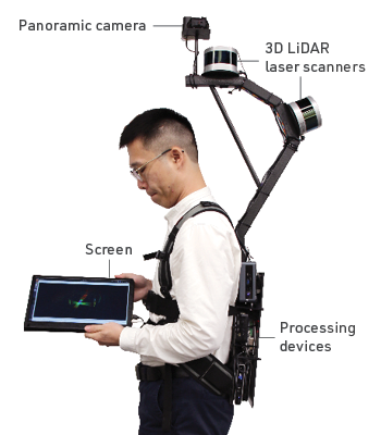
3D mobile mapping system (or the “mobile mapping backpack”)
Using a panoramic camera, 3D LiDAR (Light Detection and Ranging) laser scanners, a screen and processing devices, the System can switch seamlessly between indoor and outdoor environments without needing to be reconfigured. It uses advanced technologies, such as Simultaneous Localisation and Mapping (SLAM), which is not restricted to areas that can receive signals from the Global Navigation Satellite System (GNSS). The System can be used to build spatial data infrastructure capable of supporting smart city applications in many fields. It is particularly suitable for use in high-density and complex urban landscapes.
Construction industry applications
3D mapping is increasingly being used in construction projects. More than 10,000 residential buildings in Hong Kong are at least 50 years old, according to 2019 statistics. But most of these old buildings do not have 3D indoor modelling data, which creates challenges for reconstruction and maintenance. With the help of PolyU’s mobile mapping backpack, 3D data for these decades-old buildings can be easily obtained. The data can then be used to create Building Information Models, enabling construction professionals to carry out design work in a virtual environment and construction work in the physical world.
Currently, the research team is also partnering with the Construction Industry Council to use the backpack to obtain 3D measurements for different road sections. By identifying narrow roads and obstacles, the mobile mapping backpack technology helps identify optimum routes for transporting oversized objects such as building components. The technology can even help obtain detailed indoor 3D models to support firefighting and provide evacuation routes for people caught in a fire.
Looking ahead, Professor Shi aims to provide comprehensive solutions for smart city development through SCRI, supporting the initiatives of the “Hong Kong Smart City Blueprint 2.0”, bringing benefits to the public and industry with innovations and new technologies.


