Advancing Underground Utility Inspection with Multichannel GPR Positioning Enhancement
Other Articles

Transforming the Way We Detect Hidden Networks Beneath Our Feet
Study conducted by Ir Prof. Wallace Wai Lok LAI  and his research team
Deep in the heart of every modern city lies a labyrinth of underground utilities, including water pipes, energy conduits and communication cables, that quietly sustain daily life. Yet, as these networks age and urban density increases, the risk of undetected anomalies such as leakages, voids and subsidence grows, threatening both infrastructure integrity and public safety. Nowhere is this challenge more acute than in Hong Kong, where the intricate web of subterranean services is compounded by skyscrapers and bustling streets. Traditional inspection methods often struggle to keep pace with the City’s complexity, making early detection and precise locating of underground hazards a formidable task.
Recognising an urgent need, Ir Prof. Wallace Wai Lok LAI, Associate Head (Teaching) and Professor of the Department of Land Surveying and Geo-Informatics at The Hong Kong Polytechnic University, his PhD student Yimin ZHOU and his research team have pioneered new approaches to underground utility inspection, harnessing advanced multichannel ground penetrating radar (MCGPR) technologies. This latest study introduces a novel postprocessing framework designed to dramatically improve the positioning accuracy of MCGPR surveys, even in the most challenging urban environments. By leveraging rich data captured across multiple radar channels, this research promises to transform the way in which cities like Hong Kong manage and maintain their hidden infrastructure, supporting safer streets and more resilient communities. The result of this study is published in Measurement [1].
At the core of their breakthrough is a three-stage framework that fundamentally reconsiders how MCGPR data can be used to refine positioning accuracy. Traditionally, the reliability of GPR surveys have hinged on external positioning systems such as GNSS-RTK, which often falter amid tall buildings and dense foliage, Hong Kong’s typical cityscape. The proposed method turns the MCGPR system into a supplementary sensor, extracting underground features as reference points to reconstruct survey trajectories with unprecedented precision.
The process begins with raw trajectory classification, where positioning data from the survey are assessed for quality. Segments that meet stringent accuracy standards are retained as references, while those compromised by environmental factors, such as GNSS signal loss, are flagged for correction. This flexible classification ensures that only the most reliable data anchor subsequent reconstruction efforts.
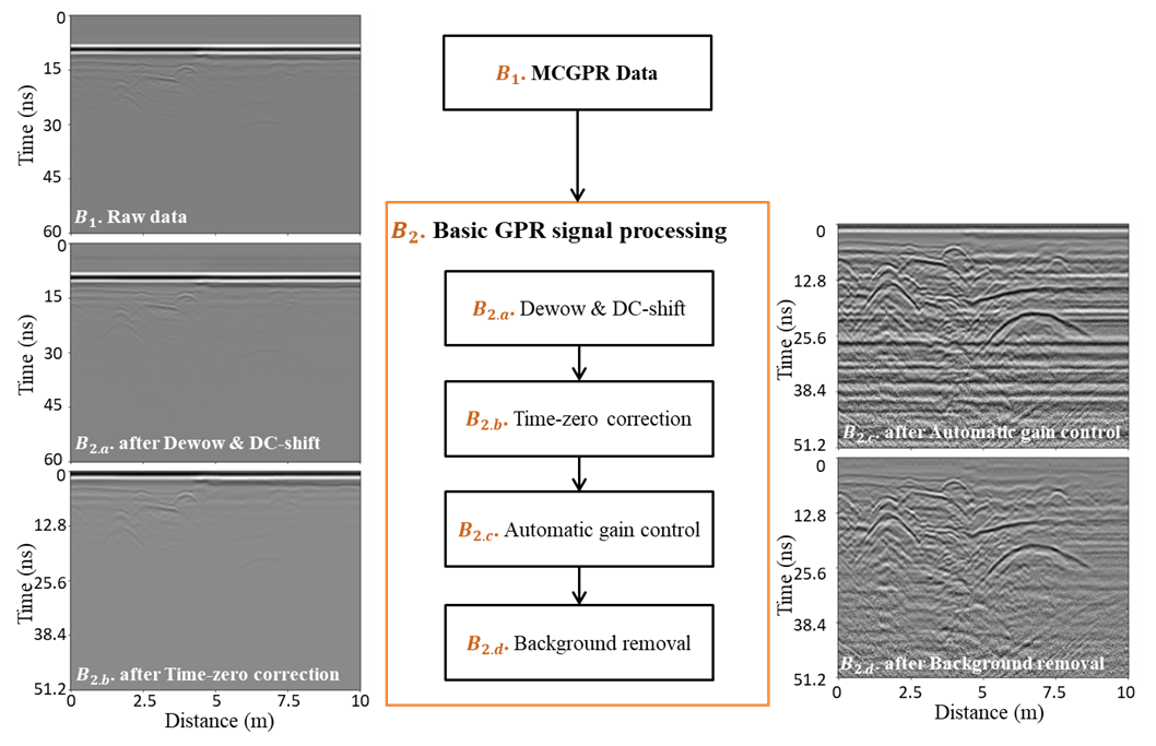
Figure 1. Workflow of basic GPR signal processing for mitigating noise and enhancing the visibility of underground features
Next comes MCGPR data processing, a critical step that prepares radar images for feature extraction. A suite of signal processing techniques is employed to mitigate noise and enhance the visibility of underground features (Figure 1). Dewow and DC-shift functions remove low-frequency artefacts and direct current bias, time-zero correction aligns antenna heights, and automatic gain control compensates for signal attenuation with depth. Background subtraction further clarifies local layers and reduces unwanted "ringing" effects, resulting in radargrams where underground features such as pipes, manholes and material interfaces stand out clearly.
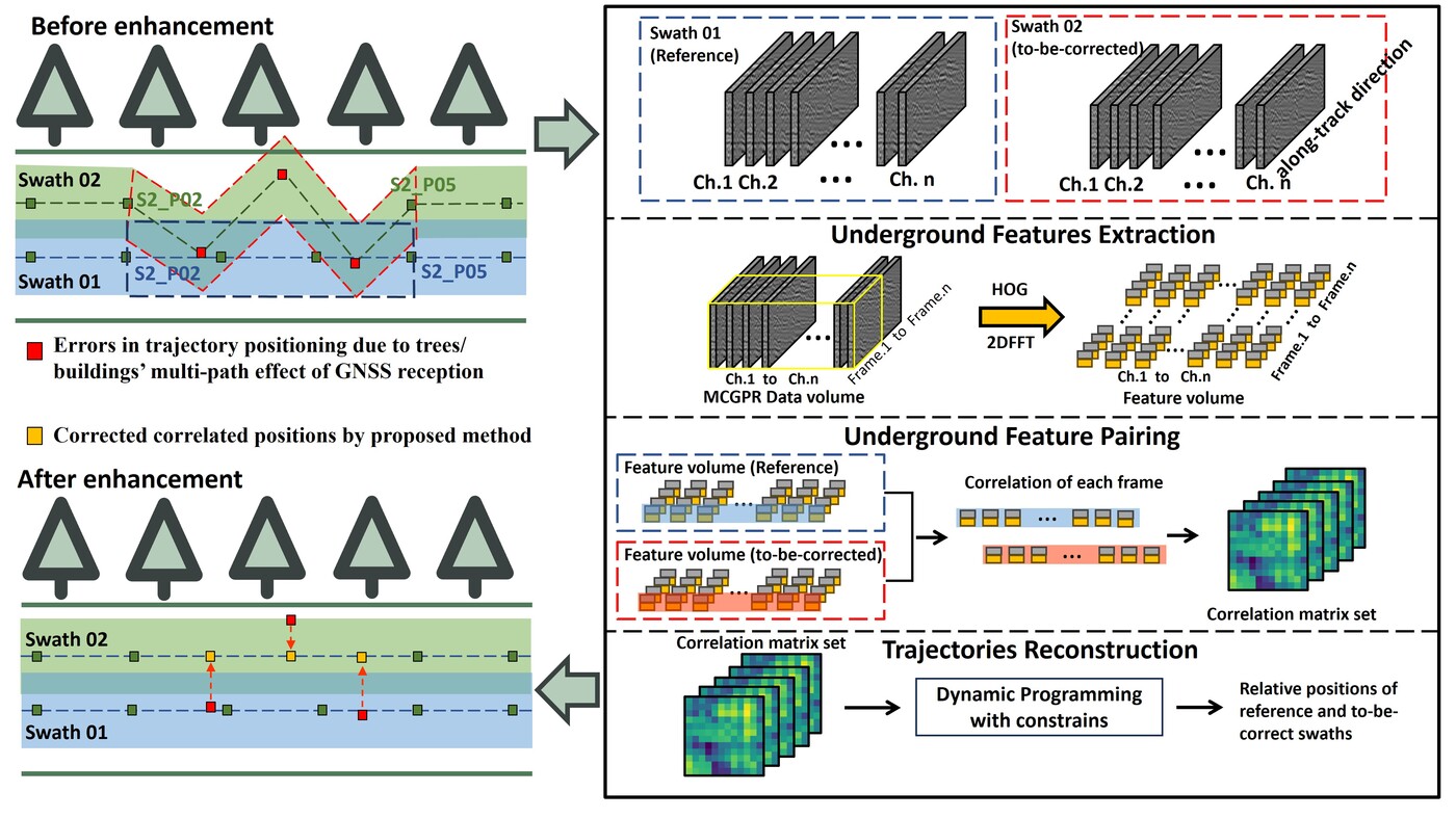
Figure 2. Workflow of MCGPR positioning enhancement [1]
The heart of the framework lies in MCGPR positioning enhancement (Figure 2), a sophisticated process that unfolds in three interconnected steps: underground feature extraction, underground feature pairing and trajectory reconstruction. Each step is meticulously designed to address the unique challenges posed by urban environments, where signal degradation and environmental complexity can severely compromise positioning accuracy.
Underground feature extraction is the first and arguably most critical step in this enhancement process. The method integrates spatial and frequency-domain descriptors, specifically the histogram of oriented gradients (HOG) and two-dimensional fast Fourier transform (2D FFT), to capture both the texture and spectral characteristics of subsurface objects.
HOG is particularly adept at identifying the shapes and edges of underground features by analysing the distribution of gradient orientations within the radar images. This approach is robust to variations in geometry and amplitude, making it well-suited for the diverse conditions encountered in urban surveys. In parallel, the 2D FFT transforms the radar data into the frequency domain, revealing patterns that may not be apparent in the spatial representation. By combining these two descriptors, the method achieves a comprehensive characterisation of underground features, balancing sensitivity to local detail with resistance to noise.
Once the features have been extracted, the next step is underground feature pairing. This involves comparing the features from overlapping survey swathes using correlation matrices, which quantify the similarity between channels. The optimal alignment is determined by tracing the diagonal path with the highest mean correlation, representing the most probable relative positions between antenna arrays. This step is essential for reconstructing the spatial relationships lost in segments where positioning data are degraded or missing.
However, the pairing process is not without its challenges. In areas where the underground environment is homogeneous or where survey swathes are closely spaced, the similarity of GPR signals can lead to ambiguities and false matches. To address this, the framework incorporates a global optimisation strategy based on a special dynamic programming (DP), which forms the final step in the positioning enhancement process.
Trajectory reconstruction using DP is a sophisticated optimisation technique that resolves ambiguities by considering the temporal continuity of the survey path. Rather than relying solely on local feature matches, DP integrates information from preceding and subsequent frames, ensuring that the reconstructed trajectory is both geometrically plausible and consistent with actual survey movements. A key innovation in this approach is the incorporation of constraints based on realistic driving behaviours, such as limits on turning angles between consecutive trajectory points. This prevents the reconstruction of implausible paths like extreme turns or sudden shifts.
The efficacy of this approach was rigorously validated across three test sites using the Raptor45 MCGPR system paired with GNSS-RTK, achieving errors at the tens of millimetres level. Notably, over 95% of reconstructed points maintained errors below the 8.4 cm separation between antennas, underscoring the method’s reliability.
The validation process included both controlled experiments, where ground truth was available, and real-world scenarios designed to emulate the challenges of urban surveys.
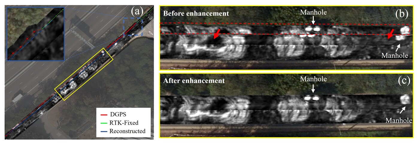
Figure 3.(a) GNSS trajectories and reconstructed trajectories; Amplitude slices (b) before and (c) after positioning enhancement
In one urban survey, GNSS signals degraded near tree canopies, causing significant drift and long-distance positioning loss. The proposed method was able to reconstruct the affected trajectories using only the MCGPR data, restoring alignment of high-reflection features such as manholes and dramatically improving the coherence of radar slices (Figure 3). Visual comparisons revealed that objects previously mismatched due to drift were now accurately positioned, validating the method’s ability to overcome the limitations of external positioning systems in complex environments.
The impact of this research extends beyond positioning enhancement. In collaboration with the Water Supplies Department, Prof. Lai's team launched the Q-Leak training centre, a pioneering initiative aimed at advancing underground water mains leak detection. The Q-Leak project also supported research into new GPR-based methods for characterising water leakage, such as the use of instantaneous frequency slices to enrich detection capabilities [2]. The team is now exploring AI and robotic solutions to collect sound data directly from within pipelines, further improving localisation and enabling immediate repair.
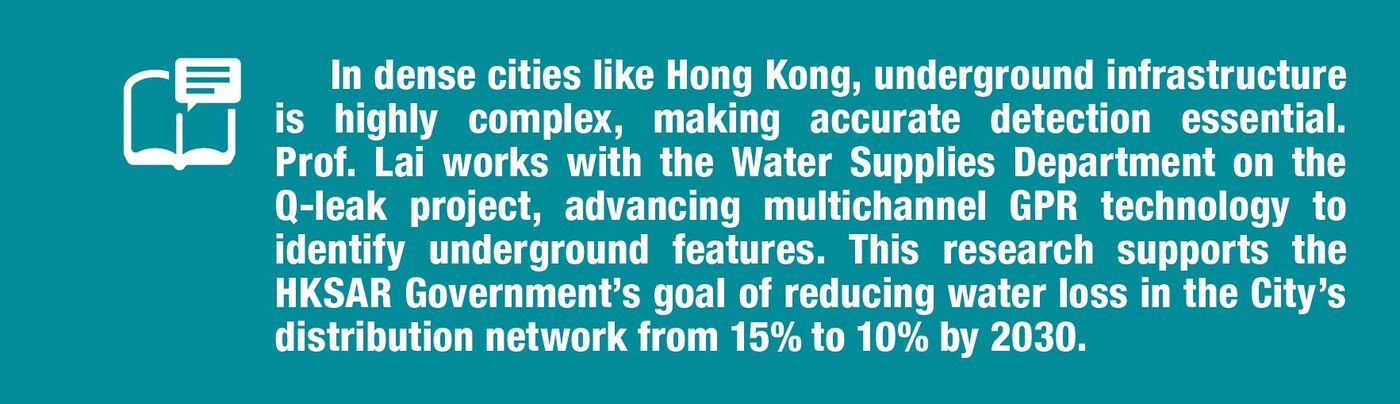
Prof. Lai has been recognised for his outstanding contribution to smart city development and awarded a Smart Living Partnership Award 2023/24 by ETNet in the "Smart Building/Environment Technology/Green Technology" category. His Q-Leak project supports the Government’s goal of reducing water loss in the City’s distribution network from 15% to 10% by 2030. Prof. Lai has chaired committees, working groups and a government task force to set up six utility survey specifications leading to the world-first accreditation scheme, and assisting in the training of over 100 professionals in other countries including Malaysia and Singapore. He is also a technical assessor for the Hong Kong Accreditation Services of Innovation and Technology Commission of the HKSAR Government.
| References |
|---|
[1] Zhou, Y., Wong, P. T. W., Li, Y., Lai, W. W. L. & Wang, J. (2026). Enhancing multichannel ground penetrating radar (MCGPR) positioning using cross-channel data, Measurement, Volume 257, Part B, 2026, 118715, ISSN 0263-2241, https://doi.org/10.1016/j.measurement.2025.118715.
[2] Zhou, Y. & Lai, W. W. L. (2024). Characterization of leakage signatures in buried water pipes by ground penetrating radar(GPR) and instantaneous frequency analysis, Tunnelling and Underground Space Technology, Volume 153, 2024, 105984, ISSN 0886-7798, https://doi.org/10.1016/j.tust.2024.105984.
 | Ir Prof. Wallace Wai Lok LAI |