Overcoming Urban-Canyon Positioning Challenges
Other Articles

3D LiDAR-Aided GNSS-RTK Tackles Signal Blockage and Poor Satellite Geometry
Study conducted by Prof. Li-Ta HSU and his research team
Global navigation satellite systems (GNSS) support applications ranging from everyday navigation to autonomous driving and low-altitude drone operations. With real-time kinematic (RTK) corrections, GNSS can achieve centimetre-level accuracy in open environments. That performance, however, can deteriorate sharply in urban canyons.
Buildings, trees and large vehicles such as double-decker buses may block direct satellite signals or reflect them before they reach the receiver. These non-line-of-sight (NLOS) measurements contain substantial errors that can corrupt the estimated position. Obstructions also reduce the number and spatial distribution of visible satellites, weakening positioning geometry and making it harder to resolve the integer ambiguities needed for precise RTK solutions.
In a recent study published in IEEE Transactions on Instrumentation and Measurement [1], Prof. Li-Ta HSU, Associate Professor of the Department of Aeronautical and Aviation Engineering at The Hong Kong Polytechnic University, and his research teams, address this problem by tightly integrating 3D LiDAR with GNSS-RTK and an inertial sensor. The resulting system improved positioning accuracy by more than 70 % compared with conventional GNSS-RTK in challenging urban environments while remaining suitable for real-time operation.
One system combines global position, local geometry and motion
The proposed approach combines three complementary sources of information. Figure 1 shows the overall pipeline of the tightly coupled system. GNSS-RTK provides global position measurements, an inertial measurement unit tracks short-term motion and a 3D LiDAR continuously scans the surrounding buildings and objects. From the LiDAR data, the system constructs a live 3D point-cloud map (PCM). This map serves two essential purposes: first, it identifies which satellite signals are likely to have been reflected and are therefore unreliable; second, it generates additional “virtual satellites” that help fill geometric gaps left by the real constellation. All measurements are jointly processed in a factor-graph optimisation framework that estimates position, velocity, sensor biases and float ambiguities together.
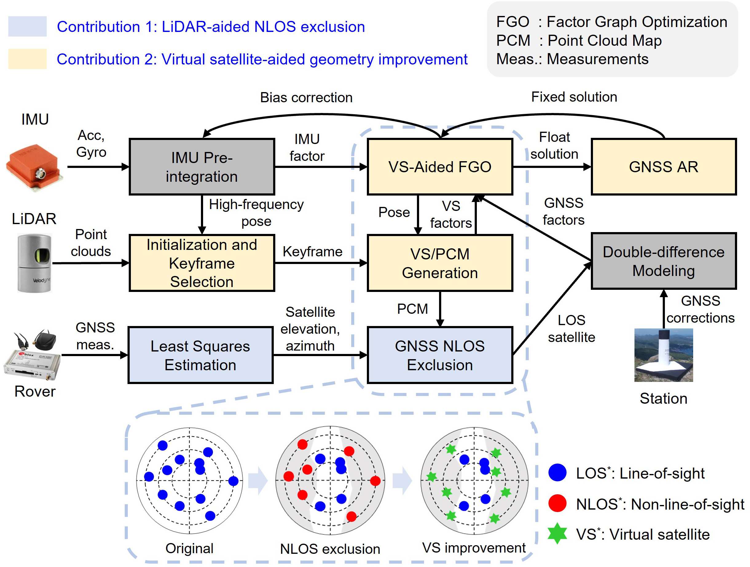
Figure 1. Pipeline overview of the proposed system
Cleaning the signals and strengthening the geometry
Two technical contributions lie at the heart of the method. The first one concerns reliable detection of NLOS signals. Earlier LiDAR-aided techniques [2] sometimes suffered from a gradual drift in the PCM, which could lead to incorrect visibility decisions. The new system corrects this drift through periodic global pose-graph optimisation that incorporates the improved GNSS solutions. Figure 2 illustrates how a drift-free PCM improves NLOS detection compared with a drifted map. With an accurate, drift-free map, the algorithm searches along each satellite’s line of sight and checks for intersections with mapped structures, allowing contaminated measurements to be excluded before they affect the solution.
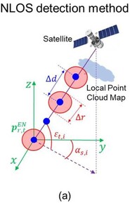
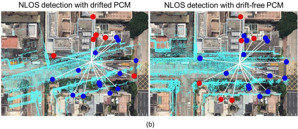
Figure 2. Illustration of the proposed 3D LiDAR-aided NLOS detection based on a drift-free PCM.
(a) Details of the method
(b) Comparison of satellites’ occlusion in the same epoch by a drifted and a drift-free PCM. Red dots represent NLOS satellites and blue dots are LOS satellites
The second contribution addresses poor satellite geometry. After NLOS exclusion, only high-elevation satellites often remain, leaving large uncertainty in the cross-street direction. Planar features extracted from the LiDAR scans are therefore treated as virtual satellites. These virtual observations supply useful constraints at lower elevation angles and significantly improve the overall geometry. To keep the system efficient, only about 200 carefully selected LiDAR features are used in each optimisation window, and their weights are dynamically balanced against the real GNSS measurements so that neither sensor dominates. The complete process, including integer ambiguity resolution, takes an average of approximately 70 ms, which supports real-time operation.
Results from one of Hong Kong’s most challenging urban canyons
The method was evaluated on three challenging sequences from the open-source UrbanNav dataset, collected in Hong Kong. Figure 3 shows the longest and most difficult trajectory in the evaluation. Lasting roughly 25 minutes, it passes through areas of dense high-rise buildings, tree cover and frequent double-decker buses—conditions that severely degrade conventional GNSS-RTK.
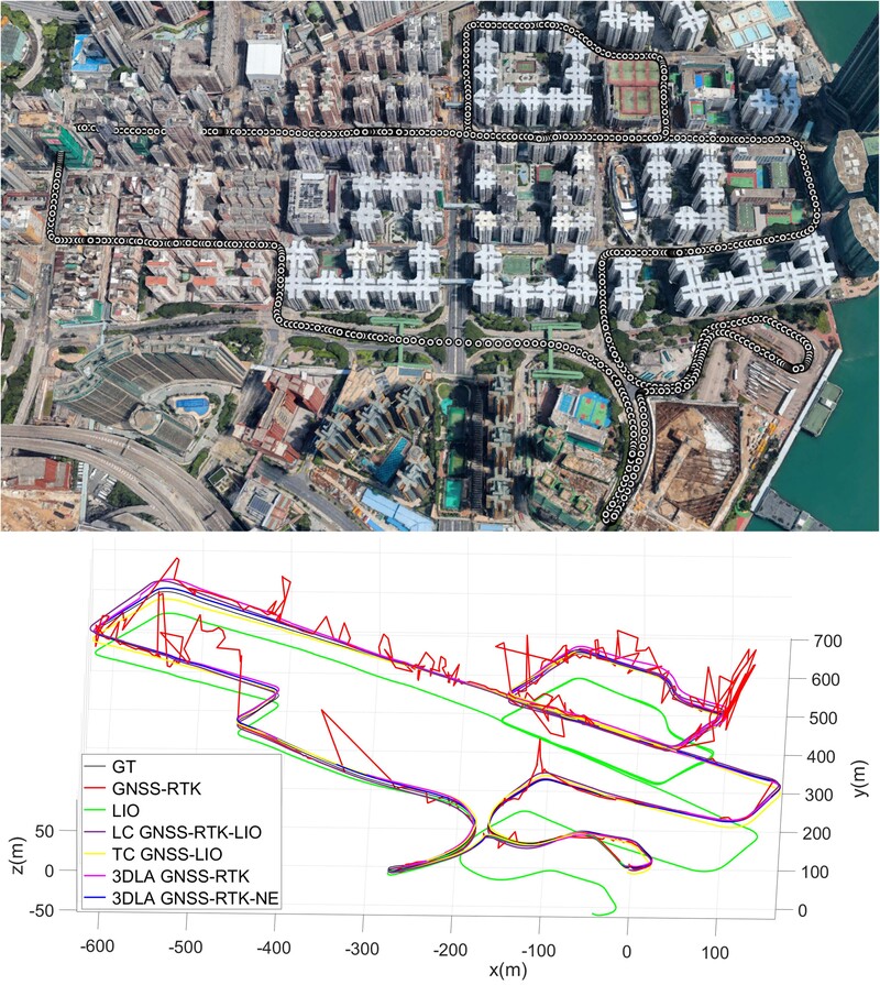
Figure 3. Trajectory in a highly urbanised area. The upper image shows the trajectory projected on Google Earth. The lower image shows the 3D trajectories produced by different methods
In this environment, the conventional GNSS-RTK solution produced a mean 3D error of nearly 10 m, with peaks approaching 100 m. The ambiguity-fixing rate was only about 1.2 % and positioning was available for just 60 % of the time. When the same data were processed with the proposed LiDAR-aided system, the mean 3D error fell to approximately 2.1 m and the largest errors were reduced to around 6 m. The ambiguity-fixing rate rose to nearly 9 %, and continuous solutions were maintained throughout the trajectory. These figures represent an improvement of roughly 78 % in average accuracy compared with standalone GNSS-RTK.
Consistent gains were observed in the two shorter sequences as well. In the least complex canyon, the method achieved a mean 3D error of 0.44 m. In the intermediate canyon, the corresponding figure remained below 0.8 m. Across all tests, the combination of reliable NLOS exclusion and virtual-satellite geometry improvement proved decisive. The system also demonstrated that a relatively small number of well-chosen LiDAR features is sufficient to constrain the state effectively, offering a practical balance between accuracy and computational cost.
Contribution of the improvement
Dependable positioning is a foundational requirement for both smart transport and the emerging low-altitude economy. Delivery drones operating between buildings, future air-taxi corridors above city streets and autonomous or highly automated ground vehicles all need continuous, trustworthy location information. Errors of tens of metres are simply unacceptable for safe navigation or precise landing. By reducing mean errors from nearly 10 m to about 2 m in the most difficult test, and to below 1 m in the two easier ones, while maintaining real-time performance, the demonstrated approach helps to lower a significant practical barrier. It also suggests that GNSS-RTK, when aided by LiDAR and inertial sensing, can reach sub-metre to metre-level accuracy even in demanding urban conditions.
Accurate positioning remains one of the most stubborn challenges for both ground vehicles and low-altitude aircraft operating in dense cities. By combining GNSS-RTK with 3D LiDAR and inertial sensing, the work presented here shows that the two classic problems of urban navigation, reflected signals and poor satellite geometry, can be substantially mitigated in real time. Tests on challenging Hong Kong urban sequences reduced average errors by more than 70 % compared with conventional GNSS-RTK and kept the system running at a practical computational cost. The result is a clearer path toward the reliable, metre-level positioning that smart transport and the low-altitude economy will need if they are to operate safely at scale.
Prof. Hsu was recognised by Stanford University as one of the top 2% most-cited scientists worldwide (career-long) in the field of networking and telecommunications for three consecutive years, from 2024 to 2026, and one of the top 2% most-cited scientists worldwide (single-year) for seven consecutive years, from 2020 to 2026. He also received the Per Enge Early Achievement Award from the Institute of Navigation (ION) in 2022, which recognised his outstanding accomplishments in the early stages of his career in the field of navigation, as well as his significant contributions to GNSS positioning in urban environments. He has published more than 160 journal papers, many appearing in leading international journals in the fields of navigation, intelligent transportation and aerospace systems. For 2023 and 2024, papers co-authored by Prof. Hsu received the Most Cited Manuscript Award in the journal NAVIGATION, including a factor graph optimisation study first-authored by Dr Weisong WEN. Prof. Hsu currently serves as an Associate Editor for IEEE Transactions on Aerospace and Electronic Systems and leads the Intelligent Positioning and Navigation Laboratory at PolyU, focusing on GNSS, multi-sensor fusion and reliable positioning for autonomous systems in urban environments.
| References |
|---|
[1] X. Liu, W. Wen, F. Huang, H. Gao, Y. Wang and L.-T. Hsu, 3-D LiDAR-Aided GNSS NLOS Mitigation for Reliable GNSS-RTK Positioning in Urban Canyons, IEEE Transactions on Instrumentation and Measurement, vol. 74, pp. 1-15, 2025, Art no. 9544915, doi: 10.1109/TIM.2025.3629836.
[2] W. Wen and L.-T. Hsu, 3D LiDAR Aided GNSS NLOS Mitigation in Urban Canyons, IEEE Transactions on Intelligent Transportation Systems, vol. 23, no. 10, pp. 18224-18236, Oct. 2022.
 | Prof. Li-Ta HSU Associate Professor and |