New RTK Model Halves Storm-Time Ionospheric Error
Other Articles

Nonlinear Interpolation Strengthens Centimetre-Level GNSS Positioning in Hong Kong During Solar Maximum
Study conducted by Prof. Wu CHEN and his research team
Drones and autonomous vehicles increasingly rely on continuous centimetre-level positioning. Network real-time kinematic (RTK) GNSS provides this capability by using reference stations to estimate and broadcast corrections to users in the field. Yet, GNSS signals must pass through the ionosphere, a variable layer of charged particles that can delay and distort measurements.
When these distortions change sharply across space, conventional corrections become less reliable. This is a growing concern for automated applications and emerging mobility systems, where positioning accuracy affects safety, automation, efficiency and public confidence. To address the problem, Prof. Wu CHEN, Head and Chair Professor of Satellite Navigation of the Department of Land Surveying and Geospatial Science at The Hong Kong Polytechnic University, and his research team proposed a Nonlinear Interpolation Model (NIM) designed to maintain more dependable RTK performance under challenging ionospheric conditions. The study was published in GPS Solutions [1].
The research focuses on mid- and low-latitude networks, with particular attention to Hong Kong. The results suggest that adding satellite-path information to conventional RTK interpolation can reduce positioning errors, improve ambiguity resolution and accelerate convergence during both active ionospheric conditions and an extreme geomagnetic storm.
Solar maximum is exposing a low-latitude RTK weakness
As Solar Cycle 25 moves through its peak phase, elevated solar activity continues to produce intense and variable ionospheric disturbances. Low-latitude regions are especially exposed because of the equatorial ionisation anomaly (EIA). Solar energy lifts plasma near the magnetic equator, after which it spreads towards higher latitudes and forms bands of elevated electron density.
Hong Kong lies close to the northern EIA crest. Around sunset and during post-sunset hours, ionospheric gradients can intensify rapidly. For systems relying on network RTK, this creates a serious reliability bottleneck. Receivers may take longer to achieve a fixed solution, lose an existing fix or fail to resolve carrier-phase ambiguities altogether.
The implications extend to drone corridors, autonomous logistics, mobile mapping, precision agriculture, surveying and infrastructure monitoring. These applications need not only high accuracy, but also predictable performance when atmospheric conditions deteriorate.
Why conventional linear interpolation leaves errors behind
RTK obtains high precision by comparing carrier-phase measurements from satellites at a user receiver with measurements from nearby reference stations. It must resolve integer ambiguities: the unknown whole number of carrier wavelengths between each satellite and receiver. Even small residual errors can obstruct this process.
Most network RTK systems use a linear interpolation model (LIM) to estimate ionospheric corrections at the user’s position. LIM represents delay variation principally as a linear spatial trend linked to the locations of ground stations. This assumption is often adequate for short baselines and relatively quiet mid-latitude conditions.
However, it becomes less reliable when ionospheric structure is nonlinear, dynamic and geographically uneven. These conditions are common near the EIA, during geomagnetic disturbances and across longer networks. The resulting errors can directly threaten the availability of reliable fixed solutions.
The missing satellite-path effect
The study identifies an important satellite-specific effect that conventional interpolation does not fully capture. Each GNSS signal crosses the ionosphere at an ionospheric pierce point (IPP). These points move as satellites travel across the sky, sampling different ionospheric paths and gradients.
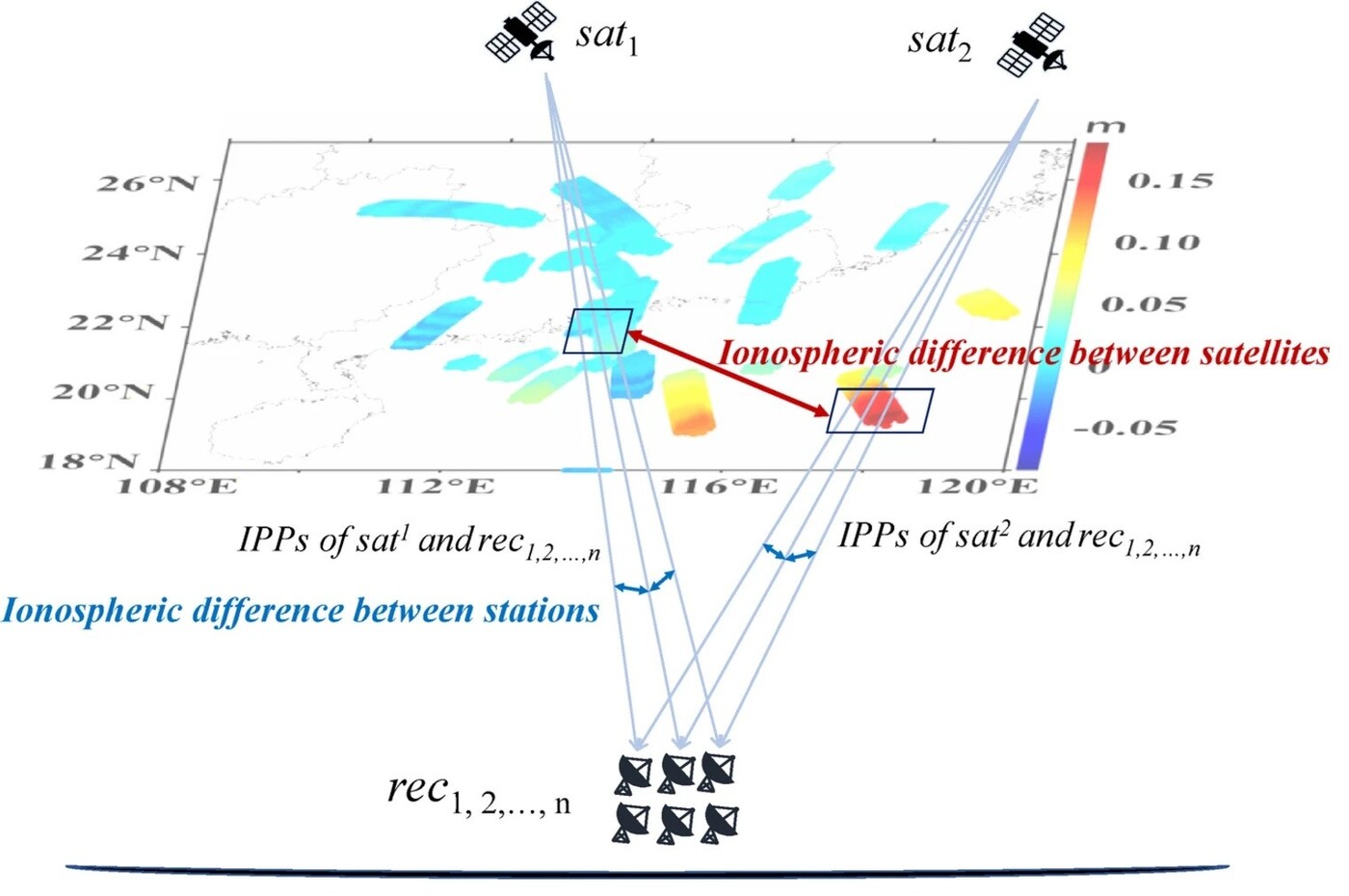
Figure 1. Schematic diagram showing ionospheric differences between satellites and between stations
Figure 1 illustrates the conceptual gap. The conventional modelled component represents ionospheric differences between ground stations. However, an additional component arises from differences between satellite IPP trajectories. This satellite-related effect remains embedded in the double-differenced ionospheric delays used by RTK processing.
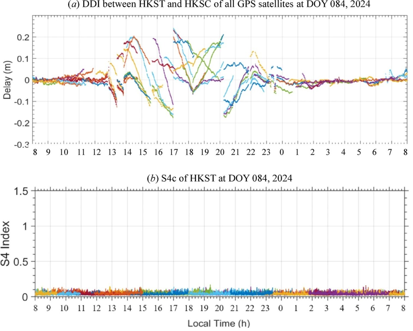
Figure 2. (a) Double differenced ionospheric delay and (b) S4 index observed on DOY 84, 2024. Different colours represent individual GPS satellites.
Because station coordinates alone do not adequately represent it, LIM cannot fully remove the residual error. Figure 2 demonstrates the problem using observations from Hong Kong reference stations. Double-differenced ionospheric delays vary particularly strongly during the sunset transition and post-sunset period. Under these conditions, the residual can approach a substantial fraction of the L1 carrier wavelength, making ambiguity fixing significantly more difficult.
30–40% lower interpolation errors with NIM
NIM addresses this omission through a dual-function spatial model. It retains a conventional station-related component, while adding a second component for nonlinear gradients along satellite IPP movement.
The new information is estimated using gradient along the IPP movement (GAIM). This method uses time-differenced dual-frequency carrier-phase observations and the distance travelled by each IPP to sense how ionospheric delay changes along its trajectory.
NIM first estimates the satellite-related nonlinear trend and detrends it from the ionospheric observations. It then models the remaining station-related linear trend. Combining both estimates produces a correction intended to more closely match the user’s local ionospheric environment.
Across the evaluation, NIM reduced double-differenced ionospheric-delay interpolation errors by roughly 30–40% compared with LIM when gradients were most significant. The improvement is important because more accurate corrections bring float ambiguity estimates closer to their integer values, increasing the likelihood of a fast and reliable fixed solution.
Hong Kong mean error falls from 1.11 cm to 0.72 cm
The active-day Hong Kong experiment provides a practical example. Using a 9.3-kilometre connection between the HKST master station and HKSC user station, the team compared NIM and LIM on 24 March 2024.
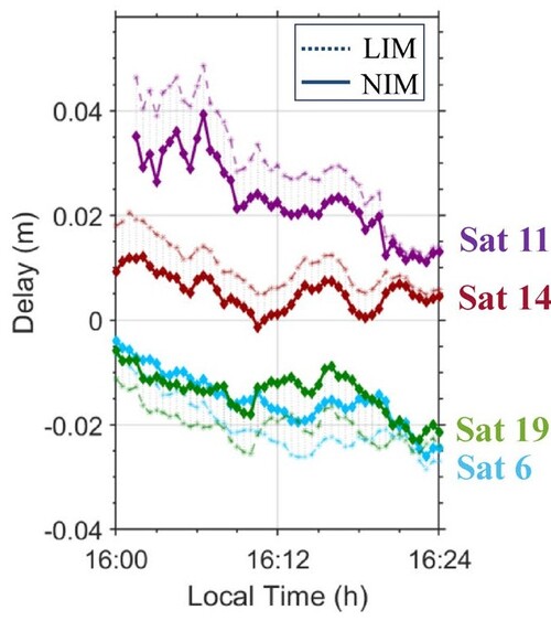
Figure 3. Comparison of ionospheric interpolation accuracy on 24 March 2024 via LIM and NIM
Figure 3 shows that NIM retained lower errors as ionospheric activity intensified from noon onwards. Between 14:00 and 16:00 local time, LIM produced errors exceeding 3 cm for several satellite tracks, while NIM generally remained below that level. For selected satellites, NIM improved precision by approximately 0.5–1 cm.
Across the active noon-to-midnight interval, mean interpolation error fell from 1.11 cm with LIM to 0.72 cm with NIM. Root-mean-square (RMS) error decreased from 1.47 cm to 0.99 cm. These differences may appear modest in absolute terms, but centimetre-scale residuals can determine whether ambiguities fix correctly, convergence slows or a receiver remains in lower-accuracy float mode.
Storm-time RMS error falls from 4.0 cm to 2.1 cm
Storm-time performance was even more striking. The May 2024 geomagnetic storm provided an exceptionally severe test, with the disturbance reaching a Dst index of −413 nT on 11 May. Strong electric fields and solar-driven disturbances increased total electron content and sharpened spatial gradients near the EIA.
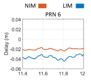
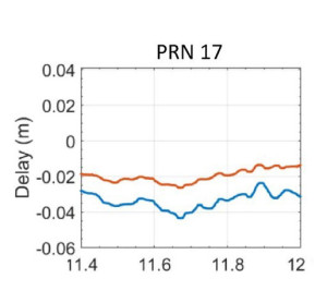
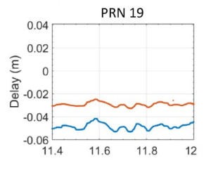
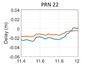
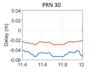
Figure 4. Comparison of the results obtained from NIM and LIM on 12 May 2024 against the reference values from double-difference ionospheric delays
In Figure 4, NIM reduced interpolation errors for several satellites by approximately half on 12 May. For one representative signal, error fell from 4 cm with LIM to 2 cm with NIM. During the storm’s most active periods, NIM maintained interpolation accuracy below 2 cm for selected satellites where LIM exceeded 3 cm.
Across the storm interval, mean error declined from 2.4 cm to 1.1 cm, while RMS error fell from 4.0 cm to 2.1 cm. The three-sigma error range also narrowed from 9.5 cm to 5.0 cm. These results show that NIM remained more stable precisely when conventional linear interpolation was under the greatest pressure.
Ambiguity-resolution success improves by up to 10%
Improved ionospheric corrections translated directly into stronger positioning performance. During active periods, NIM increased instantaneous ambiguity-resolution success by 9.4% and continuous-epoch success by 7.6%. Around 14:00, success rates rose from roughly 60% under LIM to more than 80% with NIM.
The May storm assessment also found that NIM reduced average convergence time from approximately 2.7 seconds to 1.8 seconds, an improvement of around one-third. Positioning errors became more tightly distributed in both horizontal and vertical directions.
The reported positioning precision reached about 1.1 cm horizontally and 3.8 cm vertically. For a drone, faster fixing can support dependable take-off, route entry and recovery after a brief signal interruption. For intelligent transport, it can also improve confidence in automated decisions, navigation and control.
Better corrections strengthen RTK operations
NIM’s advantage is operational as well as numerical. By addressing both station-related and satellite-path-related ionospheric variation, it improves the correction supplied to the user without abandoning the established network RTK architecture. This suggests that better modelling could complement, rather than simply replace, investment in denser reference-station networks.
NIM offers a practical advance for network RTK in regions vulnerable to strong ionospheric gradients. The results show that explicitly incorporating IPP trajectory information can reduce interpolation errors by 30–40%, nearly halve storm-time RMS error and improve both convergence and ambiguity resolution.
As solar activity remains elevated, this resilience will become increasingly important. For Hong Kong and other low-latitude regions, nonlinear interpolation could help make centimetre-level GNSS positioning more dependable when the ionosphere is most disturbed. This would strengthen the positioning foundation needed for scalable drone services, autonomous mobility and intelligent transport during Solar Cycle 25 and beyond.
Prof. Chen has been engaged in satellite positioning research for over four decades, with expertise in GNSS positioning and applications, network RTK, ionospheric effects, seamless urban navigation and multi-sensor integration. His work has been recognised through a series of awards, including the Smart Living Partnership Awards in 2022, the Hong Kong Smart City Awards in 2018, a Silver Medal at the Special Edition 2021 Inventions Geneva Evaluation Days, a Silver Medal at the International Exhibition of Inventions Geneva in 2023 and a Gold Medal in 2024. In 2026, Prof. Chen’s project “Hong Kong GNSS signal quality monitoring and interference detection system”, Hong Kong’s first GNSS signal quality monitoring and interference detection platform, won a 2026 Edison Award. Through more than 300 publications and numerous funded projects, Prof. Chen has made sustained contributions to improving the reliability of high-precision positioning, particularly under the demanding ionospheric conditions of low-latitude regions such as Hong Kong.
| References |
|---|
[1] Liu, T., Chen, W., Mi, X. et al. Ionospheric nonlinear interpolation model for Mid- and Low-latitude network RTK during solar maxima. GPS Solutions 30, 7 (2026). https://doi.org/10.1007/s10291-025-01976-9
 | Prof. Wu CHEN Head and Chair Professor of Satellite Navigation, |