
Greenland Getting Greener as the World’s Largest Ice Sheet Melts

International research team is studying meltwater patterns to accurately predict rises in global sea-levels
The 10th century Norse explorer Erik the Red discovered “Greenland” and established the first European settlement on the unforgiving island, 80% of which is covered by a 1.7 million km² ice sheet. To attract as many settlers as possible, Erik purposefully avoided any association with ice when naming the island. Today, the ice he worried might put people off is vanishing at the alarming rate of 30 million tonnes every hour, prompting an urgent scientific investigation into its impact on rising sea level.
A symbol of climate change
The stark contrast between Greenland’s name and its frozen nature is a powerful metaphor for our changing climate. At around 3 km thick, the Greenland Ice Sheet is the second-largest ice mass on Earth. If it were to melt entirely, global sea levels could rise by seven metres. Due to global warming, especially Arctic warming, the Greenland Ice Sheet melting is currently the largest contributor to global sea level rise and coastal inundation. Yet, the processes of water accumulation and release within the ice remain largely unknown.
In collaboration with an international research team, Professor Chen Jianli from PolyU’s Department of Land Surveying and Geo-Informatics and Research Institute of Land and Space has made important progress in understanding the hydrological processes of Greenland’s ice sheet. The team’s study, published in the peer-reviewed scientific journal Nature, explores how ice movement affects global sea levels.
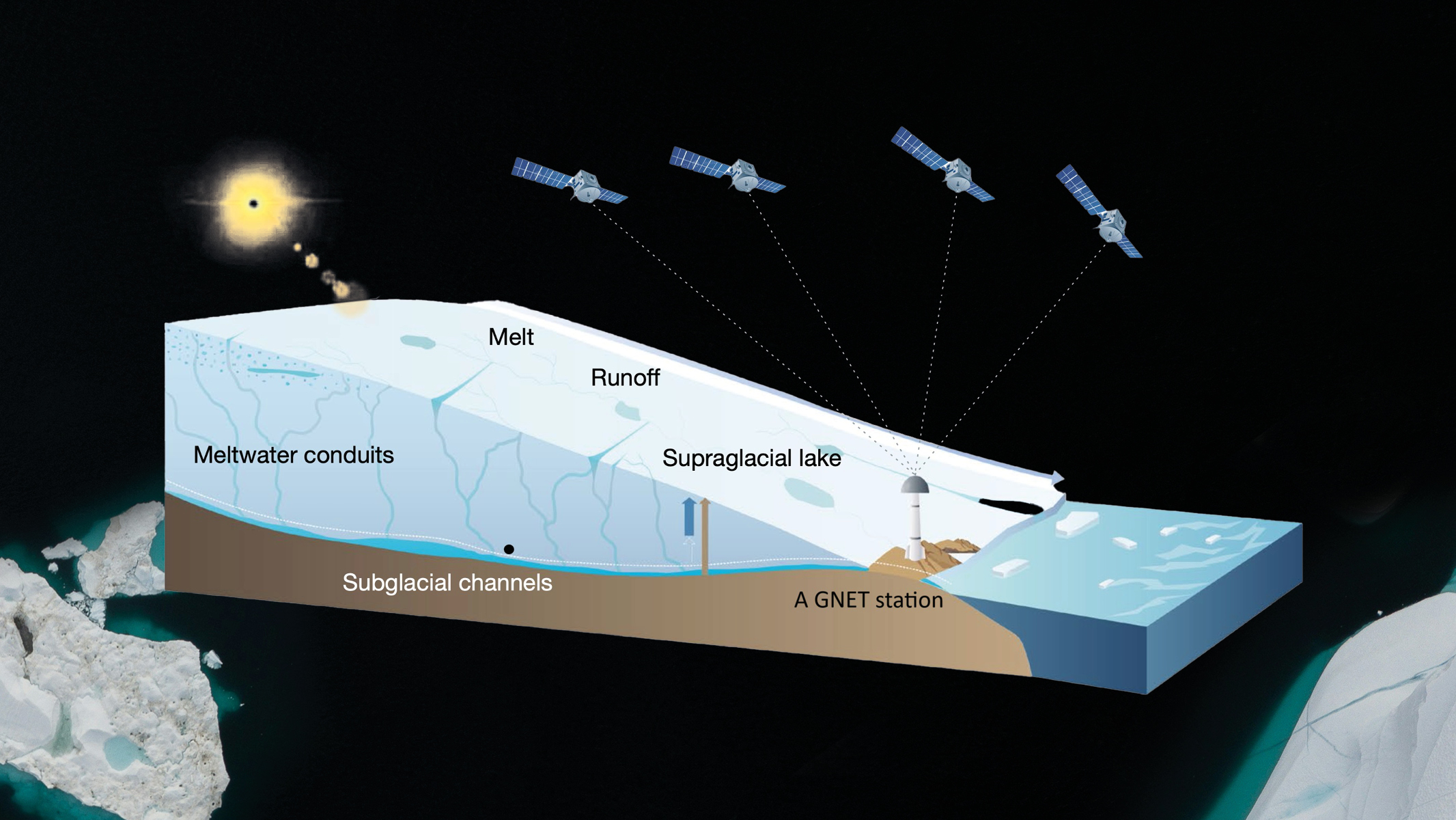
GNET and satellite gravity measurements are helping PolyU researchers to study meltwater patterns within the Greenland Ice Sheet.
Innovative approach to investigating Greenland’s ice dynamics
The conventional method for detecting changes in terrestrial water storage relies on data collected from two identical spacecraft that fly 220 km apart in a polar orbit 500 km above Earth. However, due to the coarse spatial resolution and accidental removal of useful data when filtering noise, such method is not the best choice when it comes to conducting a regional-specific assessment of Greenland’s hydrology.
The research team has pioneered the use of the Greenland GPS Network (GNET), coupled with satellite gravity measurements from NASA’s Gravity Recovery and Climate Experiment, to gain insights into regional meltwater storage and bedrock deformation and subsidence. Using data from numerous Global Navigation Satellite System (GNSS) stations around Greenland, GNET provides precise positioning data for analysis. This innovative approach has enabled the researchers to effectively monitor vertical bedrock subsidence and measure summer water storage within the Greenland Ice Sheet.
The significant results underscore the importance of extensive international cooperation in addressing climate change challenges. Our research will contribute to achieving accurate model performance for warmer years, aiding in the projection of ice-sheet behaviour and its impact on sea-level in the coming decades. This is significant amidst anticipated Arctic warmings
~ Professor Chen Jianli
Their findings reveal that a substantial amount of meltwater is temporarily stored within the ice sheet during the summer months, peaking in July before gradually diminishing. Data collected from 22 GNSS stations between 2009 and 2015 indicates that this seasonal melting contributes to bedrock subsidence of up to 5 mm near the stations, with extreme melt events in 2010 and 2012 causing subsidence of 12 and 14 mm, respectively.
The study also highlighted regional variations in the duration of meltwater storage, averaging around eight weeks across the ice sheet. In the northeast and west, storage lasted approximately nine weeks, while in the south and southeast, it averaged about four and a half weeks.
Implications for future research
As summer temperatures rise, accurately predicting meltwater storage will become increasingly critical for assessing changes in sea levels. Recent research has revealed that current meltwater runoff models, derived from regional climate projections, may have overestimated water retention and underestimated snowmelt runoff–potentially increasing predicted meltwater storage by as much as 20%. This discrepancy suggests that during the warmest years, adjustments to these models could be necessary.

Professor Chen Jianli | |
| • | Professor, Department of Land Surveying and Geo-Informatics |
| • | Member of the Research Institute of Land and Space
|


