


Publication Highlights
Effect of heat mitigation strategies on thermal environment, thermal comfort, and walkability: A case study in Hong Kong
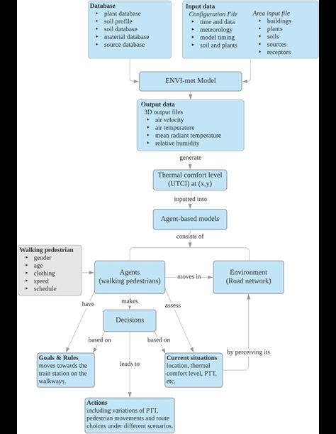
The effects of six heat mitigation strategies on thermal environment, thermal comfort, and walkability are evaluated. Thermal environment is simulated using a micro-scale computational fluid dynamic (CFD) model—ENVI-met. Thermal comfort is quantified with the Universal Thermal Climate Index (UTCI), which is linked to walkability through agent-based modeling (ABM). These integrated methods enable the quantitative assessment of how heat mitigation strategies used in urban planning affect human perceptions and behaviors. A typical high-density urban area in Hong Kong is used as a case study. Model validation reveals that the CFD model is partially accurate, performing the best in air temperature prediction. The results indicate that the type of infrastructure which causes the greatest reduction in air temperature does not necessarily lead to the biggest improvement in thermal comfort and walkability. Compared with the control, cool pavements reduce peak air temperature by 0.36, and street trees reduce peak mean radiant temperature by 4.23. Street trees also result in the lowest values of UTCI during the daytime, with a maximum UTCI reduction of 0.88. In ABM simulations, street trees cause a reduction in perceived travel time (PTT) of up to 3 s per 100 m. However, the effects of other mitigation measures are marginal. Our findings suggest that although all heat mitigation strategies can be beneficial in improving the urban thermal environment, street trees are the most beneficial for improving thermal comfort and walkability.
How to cite
Jia, S., & Wang, Y. (2021). Effect of heat mitigation strategies on thermal environment, thermal comfort, and walkability: A case study in Hong Kong. Building and Environment, 201, 107988.
Impact of temporal compositing on nighttime light data and its applications
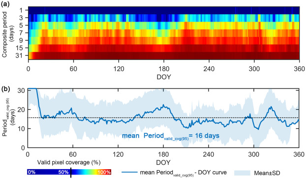
In recent decades, nighttime light (NTL) images have been widely explored to portray human footprints. Most of the studies used monthly or yearly temporal composite NTL products as a solution for invalid observations due to cloud coverage and outlier signals. However, the impact of temporal compositing on NTL data and its applications remains largely unclear. Here, we utilized over 180,000 daily NTL tiles from NASA’s Black Marble VIIRS product (VNP46A2, 2012–2020), covering 230 cities from China and the United States, to delve into the influence of temporal compositing on valid pixel coverage and spatiotemporal pattern of NTL data and the performance of three representative types of NTL-based applications. Our analysis showed temporal compositing was an imperative and efficient solution to the prevailing invalid observations. On average a 16-day composite was required to ensure at least 95% of valid pixel coverage for a city, where a longer composite period was needed for cities in a pluvial temperate climate zone. Compositing daily NTL data into a 3-day to 31-day period markedly reduced its spatiotemporal variation and incurred a 3–9 nWatts/cm2/sr, or 22%–37%, absolute difference in NTL magnitude, which was particularly high in developed cities and intra-city areas. We attributed such effect to the number of valid observations available for generating the composite data and the extremely high variation in daily NTL stemmed from human activities, as well as the uncertainties in VNP46 product and VIIRS instrument. The impact of temporal compositing on NTL-based applications varied greatly, from insignificant to very sensitive, across application types and spaces. Our analysis provides a comprehensive understanding of the capability and uncertainties in NTL data processing and applications, facilitating end-users to make the best use of NTL observations in high temporal frequency.
How to cite
Zheng, Q., Weng, Q., Zhou, Y., & Dong, B. (2022). Impact of temporal compositing on nighttime light data and its applications. Remote Sensing of Environment, 274, 113016. https://doi.org/10.1016/j.rse.2022.113016
Nighttime light remote sensing for urban applications: Progress, challenges, and prospects
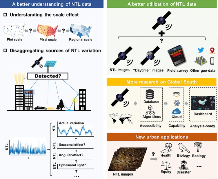
Nighttime light (NTL) remote sensing data offer unique capabilities to characterize both the extent and intensity of human activities and have been extensively used to understand urbanization since 1992. The recent proliferation of NTL sensors, algorithms, and products creates new opportunities to understand contemporary urbanization and the associated socioeconomic and environmental changes. We conducted a comprehensive literature review of 688 peer-reviewed papers published between 1992 and 2022 to understand the trends in how NTL data have been used to study urbanization (e.g., with which data products, during which time span, and in which geographies) and to synthesize the progress and challenges of key urban application topics. Based on our review, we identified four research directions for future NTL-based urban applications: (1) a better understanding of scale effects and sources of variations in NTL data; (2) integrating multi-source NTL data and synergizing NTL data with other types of geospatial data for improved NTL utilization; (3) more research on the Global South; and (4) developing new urban applications with new NTL data products. Addressing research gaps in these areas will generate new insights into the urbanization process under different geographical and socioeconomic settings.
How to cite
Zheng, Q., Seto, K. C., Zhou, Y., You, S., & Weng, Q. (2023). Nighttime light remote sensing for urban applications: Progress, challenges, and prospects. ISPRS Journal of Photogrammetry and Remote Sensing, 202, 125-141. doi:https://doi.org/10.1016/j.isprsjprs.2023.05.028
A Dual Attention Neural Network for Airborne LiDAR Point Cloud Semantic Segmentation
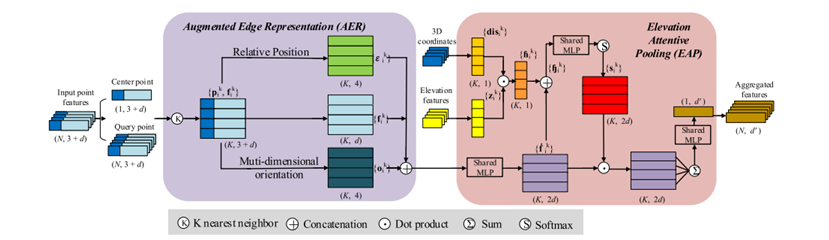
With the development of airborne light detection and ranging (LiDAR) technology, it has become a common and efficient way to collect large-scale 3-D spatial information. However, efficient and automatic semantic segmentation of LiDAR data, in the form of 3-D point clouds, remains a persistent challenge. To address this, a dual attention neural network (DA-Net) is proposed, consisting of two different blocks, namely, augmented edge representation (AER) and elevation attentive pooling (EAP). First, the AER can adaptively represent local orientation and position, thereby effectively enhancing geometric information. Second, the captured local features of centroid points are utilized to further encode discriminative features using the EAP with the learned attention scores. Finally, a location homogeneity (LH) module is devised to explore the long-range relationship in an encoder–decoder network. Benefiting from the dual attention module, geometric information hidden in unorganized point clouds can be effectively propagated. Besides, the LH forces the network to pay attention to the semantic consistency of elevated objects, which facilitates both point- and object-level point cloud semantic segmentation for scene understanding. A benchmark dataset is used to assess the proposed method, which achieves an overall accuracy of 85.98% and an average F1 score of 72.31%. In addition, comparisons with other latest deep learning methods on the 2019 Data Fusion Contest dataset further demonstrate the robustness and generalization ability of the proposed method.
How to cite
Zhang, K., Ye, L., Xiao, W., Sheng, Y., Zhang, S., Tao, X., & Zhou, Y.,2022. A Dual Attention Neural Network for Airborne LiDAR Point Cloud Semantic Segmentation. IEEE Transactions on Geoscience and Remote Sensing 1-17.
Monitoring diurnal dynamics of surface urban heat island for urban agglomerations using ECOSTRESS land surface temperature observations
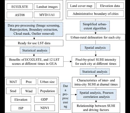
Extreme heat exposure at the regional scale is warranted for special attention due to the changing global climate yet notable regional disparities in the effect of warming. NASA’s latest ECOSTRESS mission generates LST images with a swath width of about 400 km and a 70-m resolution for varying times of day/night and provides a new opportunity for regional SUHI studies. Here we demonstrated the capability of ECOSTRESS data for studying spatiotemporal variations of LST and SUHI over an urban agglomeration that centers on a megacity, Xi’an, in Northwest China and includes cities of various sizes and geographical and economic settings. Our results revealed the unequal exposures of different-sized cities to SUHI effects in the diurnal cycle, with a maximum value of about 10 °C. Meanwhile, inter-city SUHI showed higher spatial variability in the late morning, midday, and early afternoon than in the evening, midnight, and early morning. Urban vegetation and percent imperviousness can regulate SUHI spatial variations in each city, and the impact varied across cities or at different diurnal times. The findings can have implications for assessing extreme heat exposure in regional cities, enlightening the urban SUHI mitigation strategies, and informing future regional sustainability.
How to cite
Chang, Y., Xiao, J., Li, X., & Weng, Q*., 2023. Monitoring diurnal dynamics of surface urban heat island for urban agglomerations using ECOSTRESS land surface temperature observations. Sustainable Cities and Society, 104833.
A deep learning method for building height estimation using high-resolution multi-view imagery over urban areas: A case study of 42 Chinese cities
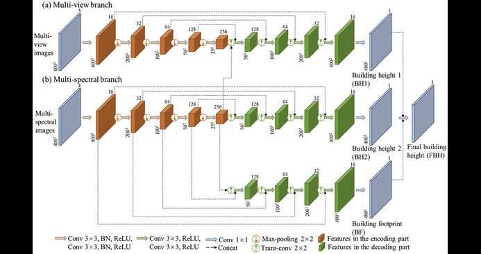
Knowledge of building height is critical for understanding the urban development process. High-resolution optical satellite images can provide fine spatial details within urban areas, while they have not been applied to building height estimation over multiple cities and the feasibility of mapping building height at a fine scale (< 5="" m)="" remains="" understudied.="" />
Multi-view satellite images can describe vertical information of buildings, due to the inconsistent response of buildings (e.g., spectral and structural variations) to different viewing angles, but they have not been employed to deep learning-based building height estimation.
In this context, we introduce high-resolution ZY-3 multi-view images to estimate building height at a spatial resolution of 2.5 m. We propose a multi-spectral, multi-view, and multi-task deep network (called M3Net) for building height estimation, where ZY-3 multi-spectral and multi-view images are fused in a multi-task learning framework. A random forest (RF) method using multi-source features is also carried out for comparison. We select 42 Chinese cities with diverse building types to test the proposed method. Results show that the M3Net obtains a lower root mean square error (RMSE) than the RF, and the inclusion of ZY-3 multi-view images can significantly lower the uncertainty of building height prediction.
Comparison with two existing state-of-the-art studies further confirms the superiority of our method, especially the efficacy of the M3Net in alleviating the saturation effect of high-rise building height estimation. Compared to the vanilla single/multi-task models, the M3Net also achieves a lower RMSE. Moreover, the spatial-temporal transferability test indicates the robustness of the M3Net to imaging conditions and building styles. The test of our method on a relatively large area (covering about 14,120 km2) further validates the scalability of our method from the perspectives of both efficacy and quality. The source code will be made available at https://github.com/lauraset/BuildingHeightModel.
How to cite
Cao, Y., Huang, X., 2021. A deep learning method for building height estimation using high-resolution multi-view imagery over urban areas: A case study of 42 Chinese cities. Remote Sens. Environ. 264, 112590.
Open-Source Data-Driven Cross-Domain Road Detection From Very High Resolution Remote Sensing Imagery
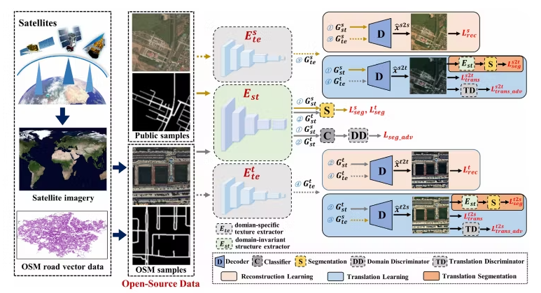
High-precision road detection from very high resolution (VHR) remote sensing images has broad application value. However, the most advanced deep learning based methods often fail to identify roads when there is a distribution discrepancy between the training samples and test samples, due to their limited generalization ability. In this paper, to address this problem, an open-source data-driven domain-specific representation (OSM-DOER) framework is proposed for cross-domain road detection. On the one hand, as the spatial structure information of the source and target domains is similar, but the texture information is different, the domain-specific representation (DOER) framework is proposed, which not only aligns the distributions of the spatial structure information, but also learns the domain-specific texture information. Furthermore, in order to enhance the representation of the target domain data distribution, open-source and freely available OpenStreetMap (OSM) road centerline data are utilized to generate target domain samples, which are then used in the network training as the supervised information for the target domain. Finally, to verify the superiority of the proposed OSM-DOER framework, we conducted extensive experiments with the public SpaceNet and DeepGlobe road datasets, and large-scale road datasets from Birmingham in the UK and Shanghai in China. The experimental results demonstrate that the proposed OSM-DOER framework shows obvious advantages over the mainstream road detection methods, and the use of OSM road centerline data has great potential for the road detection task.
How to cite
Lu X, Zhong Y, Zhang L. Open-Source Data-Driven Cross-Domain Road Detection From Very High Resolution Remote Sensing Imagery[J]. IEEE Transactions on Image Processing, 2022, 31: 6847-6862.
Cascaded Multi-Task Road Extraction Network for Road Surface, Centerline, and Edge Extraction
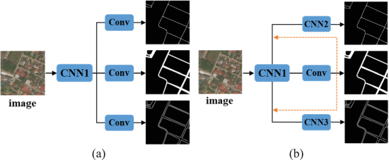
Road extraction from very high-resolution (VHR) remote sensing imagery remains a huge challenge, due to the shadows and occlusions of trees and buildings. Such complex backgrounds result in deep networks often producing fragmented roads with poor connectivity. Road extraction has three typical tasks: road surface segmentation (SS), centerline extraction (CE), and edge detection (ED), which are conducted in a wide range of real applications. Also, the three tasks have a symbiotic relationship, i.e., the road SS determines the location of the centerline and edges, and the CE and ED can allow the generation of more continuous road surfaces. However, most of the previous works have completed these three tasks separately, without exploiting the symbiotic relationship between them to boost the road connectivity. In this article, in order to improve road connectivity, a cascaded multitask (CasMT) road extraction framework for simultaneously extracting the road surface, centerline, and edges is proposed. In the proposed framework, topology-aware learning is applied to capture the long-distance topological relationships, and hard example mining (HEM) loss is employed to focus more on hard samples, to further enhance the road completeness. Extensive experiments were conducted on the DeepGlobe road dataset and a large-scale road dataset (called the LSCC dataset) from the three Chinese cities of Beijing, Shanghai, and Wuhan. The experimental results obtained on the public DeepGlobe dataset demonstrate that the proposed CasMT framework can significantly outperform the current state-of-the-art method. Moreover, the generalization capability of the model was verified on the LSCC dataset, where the proposed CasMT framework achieved the best performance in the average path length similarity (APLS) road topology metric, which further confirms the superiority of the proposed framework.
How to cite
Lu X, Zhong Y, Zheng Z, et al. Cascaded multi-task road extraction network for road surface, centerline, and edge extraction[J]. IEEE Transactions on Geoscience and Remote Sensing, 2022, 60: 1-14.
A multi-scale weakly supervised learning method with adaptive online noise correction for high-resolution change detection of built-up areas
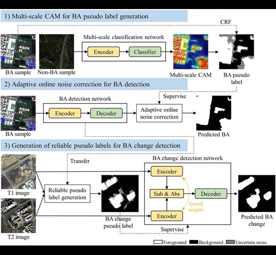
Accurate change detection of built-up areas (BAs) fosters a comprehensive understanding of urban development. The post-classification comparison (PCC) is a widely-used change detection method by classification and temporal comparison. For classification, image-level labeling is an efficient alternative to pixel-level one for pixel-wise weakly supervised segmentation, which frequently applies pixel-level pseudo labels generated from class activation map (CAM) to train semantic segmentation networks. CAM can be obtained from classification networks trained with image-level labels and can indicate the spatial location of objects. The existing studies are subject to the following issues: 1) They only rely on the single-scale and low-resolution CAM, but ignore the multi-scale property of BAs; 2) Pixel-level pseudo labels usually contain noises (e.g., omissions and false alarms); 3) The temporal correlation between multi-temporal images is less considered in PCC. To address these limitations, this paper proposed a multi-scale weakly supervised learning method, which utilized a large number of single-temporal high-resolution images and image-level labels to detect BA changes. This method consisted of three modules: 1) multi-scale CAM for BA pseudo label generation; 2) adaptive online noise correction for BA detection; and 3) generation of reliable pseudo labels for BA change detection. Based on ZY-3 images (2.5 m), we constructed the first multi-view datasets for both BA detection and change detection. Each ZY-3 image includes a multi-spectral image with red, green, blue, and near-infrared bands and a multi-view image with nadir-, forward-, and backward-views. The BA detection dataset contained 86,166 image-level samples (256 × 256 pixels for each sample), covering 48 major cities in China, while the BA change detection dataset consisted of ZY-3 bi-temporal images at rapidly urbanizing areas (i.e., Beijing and Shanghai). Experiments showed that the proposed method can detect BA changes and suppress pseudo changes effectively, yielding 88.2% F1-score in BA detection and 79.3% for Shanghai and 78.5% for Beijing in change detection. Further analysis demonstrated the proposed method to be advantageous in the following two fronts: 1) the image-level weak labels can achieve pixel-wise BA change detection at low cost; and 2) the multi-scale CAM and temporal correlation are effective in the scenarios with limited labels. Datasets and codes will be accessed at https://github.com/lauraset/MSWS.
How to cite
Cao, Yinxia, Xin Huang, and Qihao Weng. “A multi-scale weakly supervised learning method with adaptive online noise correction for high-resolution change detection of built-up areas.” Remote Sensing of Environment 297 (2023): 113779.
Cross-domain road detection based on global-local adversarial learning framework from very high resolution satellite imagery
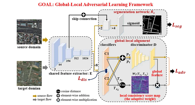
Road detection based on convolutional neural networks (CNNs) has achieved remarkable performances for very high resolution (VHR) remote sensing images. However, this approach relies on massive annotated samples, and the problem of limited generalization for unseen images still remains. The manual pixel-level labeling process is also extremely time-consuming, and the performance of CNNs degrades significantly when there is a domain gap between the training and test images. In this paper, to address this problem, a global-local adversarial learning (GOAL) framework is proposed for cross-domain road detection. On the one hand, considering the spatial information similarities between the source and target domains, feature space driven adversarial learning is applied to explore the shared features across domains. On the other hand, the complex background of VHR remote sensing images, such as the occlusions and shadows of trees and buildings, makes some roads easy to recognize, while others are much more difficult. However, the traditional global adversarial learning approach cannot guarantee local semantic consistency. Therefore, a local alignment operation is introduced, which adaptively adjusts the weight of the adversarial loss according to the road recognition difficulty. Extensive experiments were conducted on different road datasets, including two public competition road datasets—SpaceNet and DeepGlobe—and our own large-scale annotated images from four cities: Boston, Birmingham, Shanghai, and Wuhan. The experimental results show that the proposed GOAL framework can clearly improve the cross-domain road detection performance, without any annotation of the target domain images. For instance, taking SpaceNet road dataset as the source domain, compared with the no adaptation method, the IOU performance of GOAL framework is increased by 14.36%, 5.49%, 4.51%, 5.63% and 15.14% on DeepGlobe, Boston, Birmingham, Shanghai, and Wuhan images, respectively, which demonstrates its strong generalization capability.
How to cite
Lu X, Zhong Y, Zheng Z, et al. Cross-domain road detection based on global-local adversarial learning framework from very high resolution satellite imagery[J]. ISPRS Journal of Photogrammetry and Remote Sensing, 2021, 180: 296-312.
Modeling gridded urban fractional change using the temporal context information in the urban cellular automata model
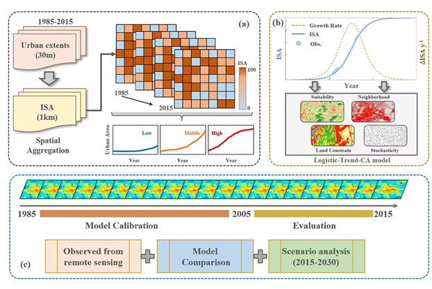
The cellular automata (CA) based models have been extensively used in urban sprawl modeling to support sustainable urban planning. However, in most existing urban CA models, only abrupt conversion (i.e., from non-urban to urban) was considered, whereas the difference in urbanization levels among different grids, as well as the nature of continuous urban evolution process with gradually increasing urban densities, were commonly ignored. Here, we proposed an impervious surface area (ISA) based urban CA model that can simulate the urban fractional change within each grid, using annual urban extent time series data from satellite observations. We implemented the developed ISA-based urban CA model in Beijing (China) and evaluated its performance through model comparison and scenario analyses. We found the ISA-based urban CA model can well capture the dynamics of urban sprawl with improved performance compared to the traditional urban CA model. The spatial pattern of modeled ISA is generally consistent with observed satellite data, with the root mean square error between the modeled and referred results of 0.14 across all changed pixels. Besides, results from our developed model agree well with the binary urban CA model, with notably reduced overestimation errors. The urban fractional change within each grid revealed in our model can provide more details than the traditional binary urban CA models, showing great potential in supporting sustainable urban development. Furthermore, the developed ISA-based urban CA model can be used for regional, even global scale urban sprawl modeling with urban fractional information in each grid, to support decision-making on the sustainable management and conservation of natural land resources.
How to cite
He W, Li X, Zhou Y, et al. Modeling gridded urban fractional change using the temporal context information in the urban cellular automata model[J]. Cities, 2023, 133: 104146.
Multi-agent reinforcement learning to unify order-matching and vehicle-repositioning in ride-hailing services
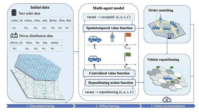
The popularity of ride-hailing platforms has significantly improved travel efficiency by providing convenient and personalized transportation services. Designing an effective ride-hailing service generally needs to address two tasks: order matching that assigns orders to available vehicles and proactive vehicle repositioning that deploys idle vehicles to potentially high-demand regions. Recent studies have intensively utilized deep reinforcement learning to solve the two tasks by learning an optimal dispatching strategy. However, most of them generate actions for the two tasks independently, neglecting the interactions between the two tasks and the communications among multiple drivers. To this end, this paper provides an approach based on multi-agent deep reinforcement learning where the two tasks are modeled as a unified Markov decision process, and the colossal state space and competition among drivers are addressed. Additionally, a modifiable agent-specific state representation is proposed to facilitate knowledge transferring and improve computing efficiency. We evaluate our approach on a public taxi order dataset collected in Chengdu, China, where a variable number of simulated vehicles are tested. Experimental results show that our approach outperforms seven existing baselines, reducing passenger rejection rate, driver idle time and improving total driver income.
How to cite
Xu M, Yue P, Yu F, et al. Multi-agent reinforcement learning to unify order-matching and vehicle-repositioning in ride-hailing services[J]. International Journal of Geographical Information Science, 2023, 37(2): 380-402.
Diurnal urban heat risk assessment using extreme air temperatures and real-time population data in Seoul
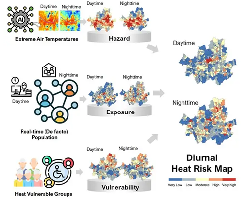
Previous heat risk assessments have limitations in obtaining accurate heat hazard sources and capturing population distributions, which change over time. This study proposes a diurnal heat risk assessment framework incorporating spatiotemporal air temperature and real-time population data. Daytime and nighttime heat risk maps were generated using hazard, exposure, and vulnerability components in Seoul during the summer of 2018. The hazard was derived from the daily extreme air temperatures obtained using the stacking machine learning model. Exposure was calculated using de facto population density, and vulnerability was assessed using demographic and socioeconomic indicators. The resulting maps revealed distinct diurnal spatial patterns, with high-risk areas in the urban core during the day and dispersed at night. Daytime heat risk was strongly correlated with heat-related illness ratios (R = 0.8) and accurately captured temporal fluctuations in heat-related illness incidence. The proposed framework can guide site-specific adaptation and response plans for dynamic urban heat events.
How to cite
Yoo C, Im J, Weng Q, et al. Diurnal urban heat risk assessment using extreme air temperatures and real-time population data in Seoul[J]. Iscience, 2023, 26(11): 108123.
Learning visual overlapping image pairs for SfM via CNN fine-tuning with photogrammetric geometry information
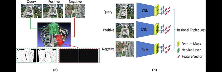
Efficient and accurate identification of visual overlapping image pairs is an ongoing challenge for large-scale Structure from Motion (SfM). Recently, CNN-based methods have demonstrated the ability to find visually similar image pairs. BoW (Bag-of-Word) or Visual Vocabulary tree (VoC) with hand-crafted or learning-based local features is yet widely embedded in 3D reconstruction tasks. To explore the corresponding differences, in this work, we fine-tuned several popular CNNs (AlexNet, VGG, ResNet) according to the regularities which are tailored for determining visual overlapping image pairs for SfM. More specifically, a new training dataset (called LOIP) consisting of regular photogrammetric images and crowdsourced images from the Internet is generated by fully considering photogrammetric requirements and 3D mesh models. The local regional overlapping information from paired images was employed in fine-tuning procedure. To aggregate feature maps from various channels, learnable multiple NetVLADs for each regional information are employed to further improve the retrieval performance. Comprehensive experiments have been conducted and the obtained results demonstrate that the image retrieval performance is improved, and the cost time of image matching is significantly reduced by applying the identifications of visual overlapping pairs. Furthermore, the SfM results are basically on par with several state-of-the-art CNN-based and VoC methods.
How to cite
Hou, Q., Xia, R., Zhang, J., Feng, Y., Zhan, Z., & Wang, X. (2023). Learning visual overlapping image pairs for SfM via CNN fine-tuning with photogrammetric geometry information. Int. J. Appl. Earth Obs. Geoinformation, 116, 103162.
Developing an intelligent cloud attention network to support global urban green spaces mapping
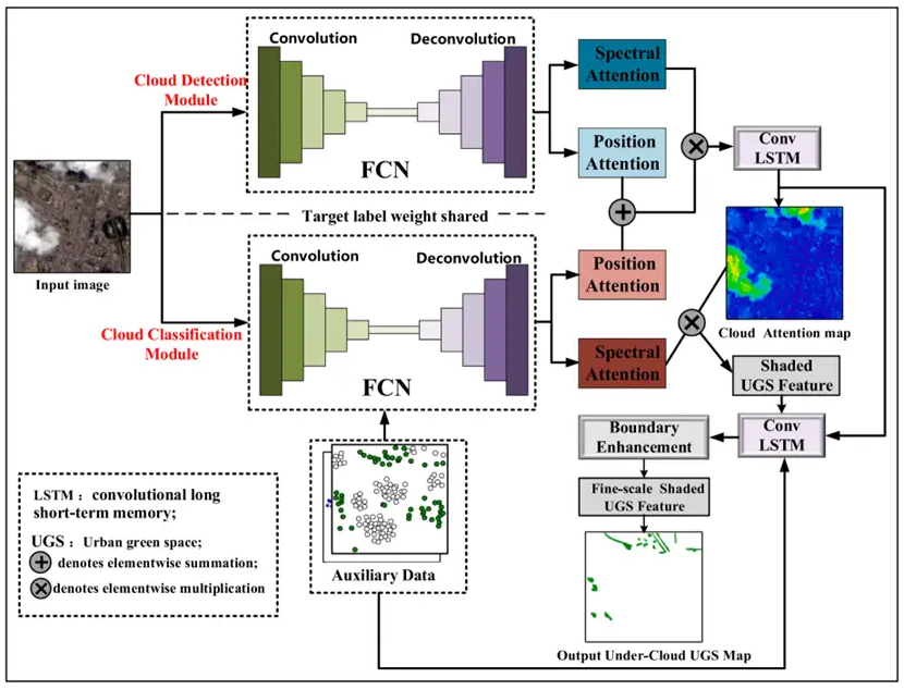
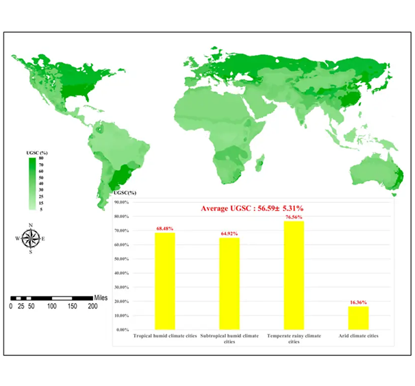
Urban green spaces (UGS) play an important role in understanding of urban ecosystems, climate, environment, and public health concerns. Satellite derived UGS maps provide an efficient and effective tool for urban studies and contribute to targets and indicators of the sustainable development goals, at the global level, set by the United Nations. However, clouds create a challenging issue in optical satellite image processing, leading to significant uncertainty in UGS mapping. In this study, we propose an automatic UGS mapping method by integrating satellite images with crowdsourced geospatial data while aiming to reduce the uncertainty caused by cloud contamination. The proposed method consists of three parts: (1) auxiliary data pre-processing module; (2) cloud attention intelligent network (CAI-net); and (3) non-cloud scenes classification module. The auxiliary data pre-processing module was used to convert crowdsourcing geospatial data into auxiliary maps. The CAI-net was proposed to retrieve detailed UGS classes within clouds from satellite image patches and auxiliary maps, while non-cloud scenes classification module was used to extract UGS from satellite image patches. The proposed method was applied to generate spatial continuous global UGS map products, considering the uncertainty caused by cloud contamination. The results show the proposed method yielded a high-quality global UGS map with average overall accuracy as high as 92.96% when satellite images had cloud coverage ranging from 0% to 50%. The geospatial AI, specifically CAI-net, can provide more accurate UGS mapping regardless of different geographical and climatic conditions of the study areas, which is especially significant for humid tropical and subtropical regions with frequent clouds and rains.
How to cite
Chen, Y., Weng, Q., Tang, L., Wang, L., Xing, H., & Liu, Q. (2023). Developing an intelligent cloud attention network to support global urban green spaces mapping. ISPRS Journal of Photogrammetry and Remote Sensing, 198, 197-209.
Cloud and cloud shadow detection for optical satellite imagery: Features, algorithms, validation, and prospects
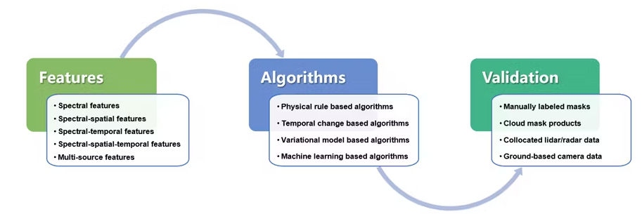
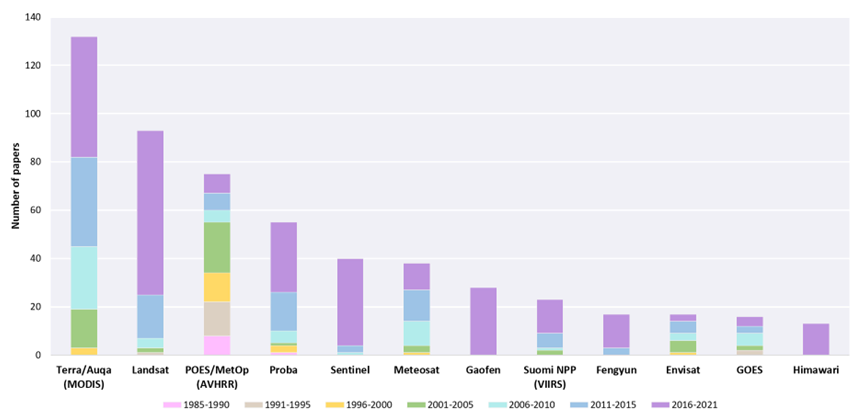
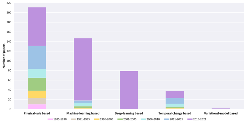
The presence of clouds prevents optical satellite imaging systems from obtaining useful Earth observation information and negatively affects the processing and application of optical satellite images. Therefore, the detection of clouds and their accompanying shadows is an essential step in preprocessing optical satellite images and has emerged as a popular research topic in recent decades due to the interest in image time series analysis and remote sensing data mining. This review first analyzes the trends of the field, summarizes the progress and achievements in the cloud and cloud shadow detection methods in terms of features, algorithms, and validation of results, and then discusses existing problems, and provides our prospects at the end. We aim at identifying the emerging research trends and opportunities, while providing guidance for selecting the most suitable methods for coping with cloud contaminated problems faced by optical satellite images, an extremely important issue for remote sensing of cloudy and rainy areas. In the future, expected improvements in accuracy and generalizability, the combination of physical models and deep learning, as well as artificial intelligence and online big data processing platforms will be able to further promote processing efficiency and facilitate applications of image time series. In addition, this review collects the latest open-source tools and datasets for cloud and cloud shadow detection and launches an online project (Open Satellite Image Cloud Detection Resources, i.e., OpenSICDR) to share the latest research outputs (https://github.com/dr-lizhiwei/OpenSICDR).
How to cite
Li, Z., Shen, H., Weng, Q., Zhang, Y., Dou, P., & Zhang, L. (2022). Cloud and cloud shadow detection for optical satellite imagery: Features, algorithms, validation, and prospects. ISPRS Journal of Photogrammetry and Remote Sensing, 188, 89-108.
