Register Now: 2026 Workshop and Tutorial in GeoAI Advancements and Applications

-
Date
11 - 12 Jun 2026
-
Organiser
Research Centre for Artificial Intelligence in Geomatics (RCAIG); JC STEM Lab of Earth Observations
-
Time
08:30 - 18:00
-
Venue
201, Wing GH, PolyU Map
Enquiry
Tresley He 2766 5924 info.poleis@polyu.edu.hk
Summary
Supported by: Department of Land Surveying and Geo-Informatics; Research Institute of Land and Space; Spatial Data Office
Overview
The 2026 Workshop and Tutorial in GeoAI Advancements and Applications will explore the forefront of geospatial artificial intelligence (GeoAI) advancements and applications in ecosystems, infrastructure, and cities. In an era where artificial intelligence (AI) is revolutionizing the fields of Earth observations, geomatics, big data, environmental sciences, and sustainable development, this workshop will immerse participants in cutting-edge AI technologies and recent advancements, demonstrate their applications to complex real-world problems, and guide the derivation of meaningful scientific insights.
Registration Options
LSGI Members: Current students and staff members of LSGI are invited to register free of charge using the link below:
External Participants: If you are not a member of the LSGI department, please proceed to our External Registration Portal or scan the QR CODE on the poster to complete your registration and payment:
Exclusive Registration Perks
All registered external participants will receive a comprehensive hospitality package on their registered day(s), including:
• Coffee breaks with refreshments
• Complimentary Lunch
• Welcome Dinner
• Official Programme Brochure
Guests of Honor
We are honored to welcome our distinguished guests:
• Mr. Duncan Chiu: Member of the Legislative Council for the Technology and Innovation functional constituency of HKSAR; President of the Hong Kong Information Technology Joint Council (HKITJC); Chairman of HKTDC Information & Communications Technology (ICT) Services Advisory Committee; and Chairman, Information Technology Services Committee of the Hospital Authority.
• Professor Jiannong Cao: Vice President (Education), Otto Poon Charitable Foundation Professor in Data Science, Chair Professor of Distributed and Mobile Computing, The Hong Kong Polytechnic University.
• Sr Professor Paul Tsui: Chief Executive Officer, Esri China (Hong Kong) Limited; Adjunct Professor, Department of Civil and Environmental Engineering, The Hong Kong University of Science and Technology.
• Mr. Keran Wang: Chief, Space Applications Section, Information and Communications Technology and Disaster Risk Reduction Division, United Nations Economic and Social Commission for Asia and the Pacific (UN ESCAP).
• Mr. Cheuk Man Yeung: Asst Dir/Survey & Mapping (Survey and Mapping Office/Headquarters)• Sr. Raymond Choi: Head of Spatial Data Office, Development Bureau, HKSAR Government
Invited Speakers
Our program features a distinguished group of global keynote speakers, including Prof. Jiannong Cao (PolyU), Prof. Michael Batty (UCL), Prof. Lan Mu (UGA), Prof. Dev Niyogi (UT Austin), Mr. Keran Wang (UN ESCAP), Prof. Maria Antonia Brovelli (PoliMI), Prof. Yu Liu (Peking), Prof. Bisheng Yang (WHU), Prof. Bo Huang (HKU), Prof. Hui Su (HKUST), Prof. Jun Li (CUG), Prof. Xiaoli Ding (PolyU), and Prof. QihaoWeng (PolyU).
We are also excited to host a lineup of invited speakers: Prof. CheolheeYoo (PNU, Korea), Prof. Jie Chen (CSU), Prof. ChunpengChen (ECNU), Prof. Ting Yun (NJFU), Dr. Hao Li (NUS, Singapore), Prof. Kazuto Ichii(Chiba U, Japan), Prof. XiaojuanQi (HKU), Prof. HongshengZhang (HKU), Prof. Bin Chen (HKU), Prof. Kai Han (HKU), Prof. Xi Chen (CUHK), Prof. George Liu (PolyU), Prof. Xiaolin Zhu (PolyU), Prof. Guoqiang Shi (PolyU), Prof. TiangangYin (PolyU), Prof. XintaoLiu (PolyU), Prof. Yang Xu (PolyU), and Prof. Catherine Liu (PolyU).
Presentation Titles
Prof. Jiannong Cao:
Towards the Future of Ubiquitous AI
Prof. Michael Batty:
The Evolution of AI in City Planning
Prof. Xiaojuan Qi:
3D Representations for World Modeling and Generation
Prof. George Liu:
NWP with GNSS Water Vapor Data Assimilation to Improve Hong Kong Rainfall Forecasting: A Comparison with AI Models
Prof. Bisheng Yang:
Embodied AI Robotics for autonomous mapping in challenging scenarios
Prof. Cheolhee Yoo:
Remote Sensing for Urban Sustainability: Tracking Heat Risk and Emissions Amid Rapid Urban Growth
Prof. Lan Mu:
Applications First: What Really Drives GeoAI in Health and Environmental Studies
Prof. Xintao Liu:
Spatial Data Science and Smart Cities in Hong Kong
Prof. Yang Xu:
Modeling Fleet Size and Parking Needs for Shared Autonomous Vehicles in Future Cities
Prof. Catherine Liu:
FMDA-SI: Flow-Matching based Data Assimilation with Sparse and Irregular observations
Prof. Hongsheng Zhang:
Multimodal Remote Sensing of Coastal Environments
Prof. Bo Huang:
Spatial Intelligence for Urban Environmental Sustainability
Prof. Yu Liu:
Towards Spatial Intelligence versus Geo-spatial Intelligence
Prof. Jie Chen:
Bridging Morphology and Function: A Morphology -Guided Multimodal Model for Global Urban Region Representation
Prof. Kai Han:
Taming Foundation Models for Spatial Intelligence
Prof. Maria Antonia Brovelli:
Consensus-Based Labeling and Foundation Model Fine Tuning for Global High-Resolution Land Cover Mapping
Prof. Xiaolin Zhu:
Applicability of AlphaEarth Foundations in mapping small objects
Prof. Guoqiang Shi:
Satellite and Deep-Learning Empowered Infrastructure Health Monitoring for Hong Kong's Reclamations
Prof. Xiaoli Ding:
GeoAI Meets InSAR: Opportunities, Challenges, and Perspectives
Prof. Tiangang Yin:
Site-to-Sensor Digital Twins: Physics-Guided AI for Enhancing Forest Information Retrieval From Remote Sensing
Prof. Bin Chen:
Multi-Dimensional Urban Sensing Empowered by Geospatial Big Data
Prof. Hui Su:
HIWindCast: A Deep Learning Model for Operational High-Resolution Tropical Cyclone Wind Forecasting
Prof. Xi Chen:
UAV-based Multimodal Sensing for Horseshoe Crab Conservation
Dr. Hao Li:
Responsible AI for Geography: Shaping A Disaster Resilient Future in the Changing Climate
Mr. Keran Wang:
Empowering the youth for innovations in geospatial applications for sustainable development
Prof. Dev Noyogi:
City Digital Twins
Prof. Jun Li:
GeoAI-Driven Heterogeneous Data Fusion for Urban Flood Monitoring
Prof. Ting Yun:
A Spherical-Harmonic Deep Learning Framework for Generic Tree Morphology and Species Identification
Prof. Kazuto Ichii:
Toward GeoAI-Driven Terrestrial Monitoring with Geostationary Satellites: High-Frequency Big Data, Downscaling, and Upscaling
Prof. Chunpeng Chen:
GeoAI for Coastal Sustainability Monitoring and Applications
Dr. Yijie Wu:
A building skeleton theory for automatic 3D reconstruction of BIM and CIM
Dr. Chouaib EL HACHIMI:
How Can Mechanistic Artificial Intelligence and Foundation Models Serve Environmental Science? Case of Evapotranspiration Mapping across Africa
Ms. Yuhan ZHOU:
Advancing global urban mapping with multimodal robustness and versatile applications
Ms. Qianbao HOU:
Multi-source geo-localization in urban built environments for crowd-sourced images
About the Workshop
The Workshop and Tutorial in GeoAI Advancements and Applications is the flagship annual event of the Research Centre for Artificial Intelligence in Geomatics (RCAIG) at The Hong Kong Polytechnic University. Now in its third year, this international forum is dedicated to exploring the forefront of Geospatial Artificial Intelligence (GeoAI) and its transformative impact on ecosystems, infrastructure, climate resilience, and urban systems.
Chaired by Professor Qihao Weng, a global leader of Earth observation and GeoAI, the workshop serves as a premier platform for researchers and practitioners from academia, industry, and government to exchange cutting-edge ideas. Its mission is to bridge the gap between AI theory and real-world implementation, focusing on the derivation of meaningful scientific insights from Earth observations and complex geospatial data and cultivating future leaders.

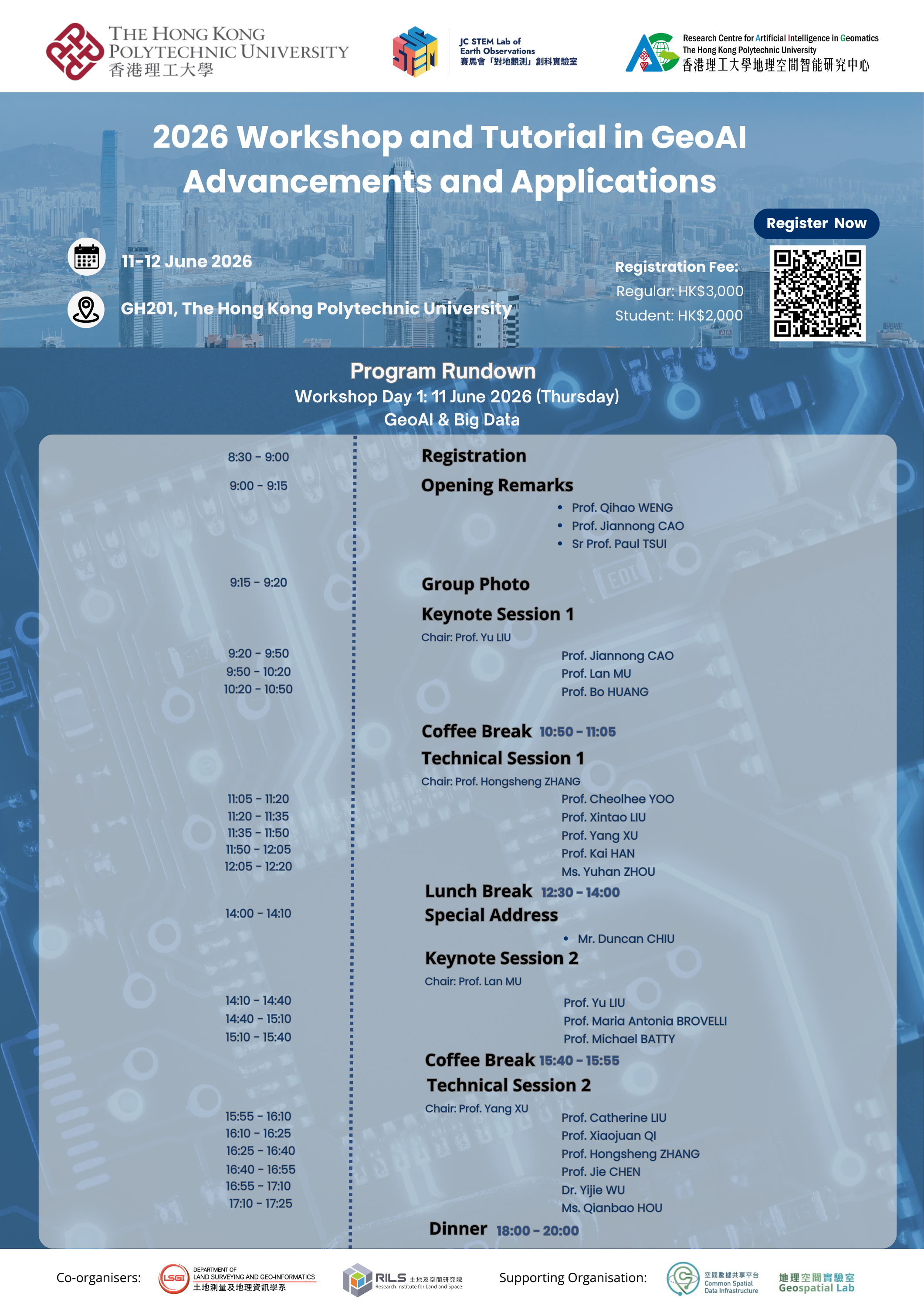
The two-day rundowns are as follows: