Road Safety Assessment using Advanced Driving Simulation Approach with 3D Geo-spatial Model
A convenient and safe transport environment is important for a densely populated city. Conventional road safety research has been relying on the historical crash record which is often subject to the problems of missing data, under reporting and random natured statistical distribution. This research aims to develop an automatic decision support tool for proactive road safety assessment that can capture the dynamic traffic operation and safety data at high accident risk locations in Hong Kong.
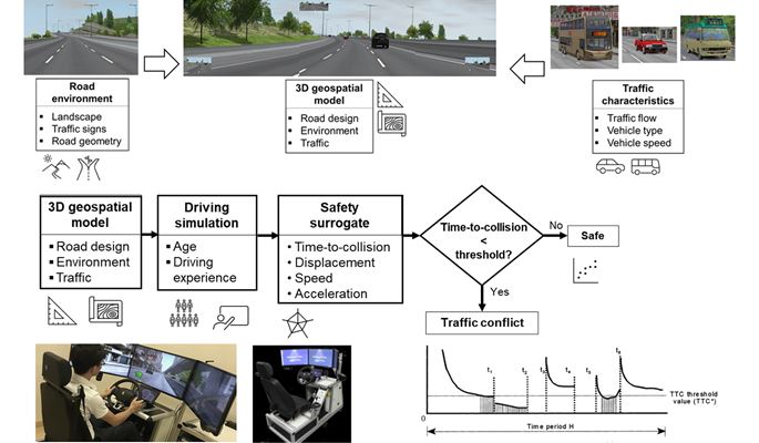
A 3D geo-spatial model would be developed to replicate the road environment and traffic characteristics of Tuen Mun Road, Tolo Highway, and Tai Chung Kiu Road for safety assessment. The risk of potential collision at crash-prone locations of the three simulated roadways would be estimated using a virtual driving simulation experiment based on integrated GIS data and computer vision technique. The results would be validated by actual traffic data captured from drone and image processing technology.
The project has received support from the Smart Traffic Fund.
(Smart Traffic Fund is funding initiated by the Transport Department to support local organisations or enterprises for conducting research and application of innovation and technology with the objectives of enhancing commuting convenience, enhancing the efficiency of the road network or road space, and improving driving safety)