
Research Interest: Sustainable and climate-friendly aviation; contrail detection and climate-impact assessment; remote sensing; machine learning; Trajectory prediction
Education
B.Eng., College of Civil Aviation, Nanjing University of Aeronautics and Astronautics, Nanjing, China, September 2015-June 2019.
M.Eng., College of Civil Aviation, Nanjing University of Aeronautics and Astronautics, Nanjing, China, September 2019-April 2022.
Ph.D, Department of Aeronautical and Aviation Engineering, The Hong Kong Polytechnic University, Kowloon, Hong Kong SAR, May 2024-present.
Employment
R&D Engineer, Autonomous Driving, DiDi Technology Co., Ltd., Shanghai, China, June 2022-April 2024.
International Visit
International Visit Student, Ecole Nationale de l'Aviation Civile (ENAC), 2026.3-2026.9
Signature research outcomes


Core Research
Research 1: Estimating Spatio-Temporal Contrail Coverage: Fusing Satellite Observations, Meteorology, and Air Traffic Flow.
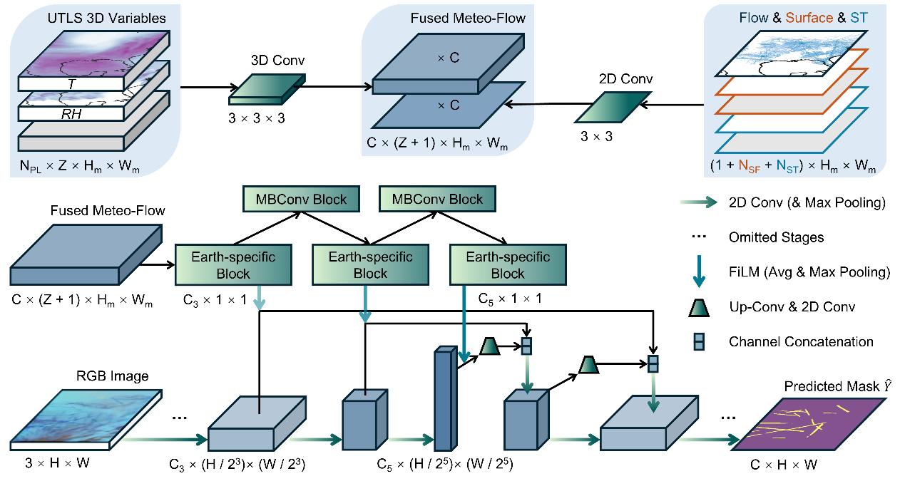
Meteo-Flow-enhanced contrail detection framework integrating satellite imagery, upper-atmosphere variables, and traffic-flow information.
This study integrates GOES-16 satellite imagery with ERA5 meteorology and air traffic flow to improve automated contrail detection and estimate long-term contrail coverage over the continental United States. Applied to more than 80,000 satellite frames, the framework estimated an average coverage of 0.133% across nine annual 31-day windows, identified contrail-intense zones and corridors, and revealed a 50.8% reduction during the COVID-19 traffic decline in 2020.
Main contributions of Research 1:
1) Developed a multi-source Meteo-Flow framework that embeds meteorological and traffic-flow priors into contrail segmentation.
2) Produced a nine-year observational estimate of contrail coverage and its diurnal and spatial patterns over CONUS.
3) Linked detected coverage changes to atmospheric conditions and aviation activity, providing evidence for targeted flight-rerouting strategies.
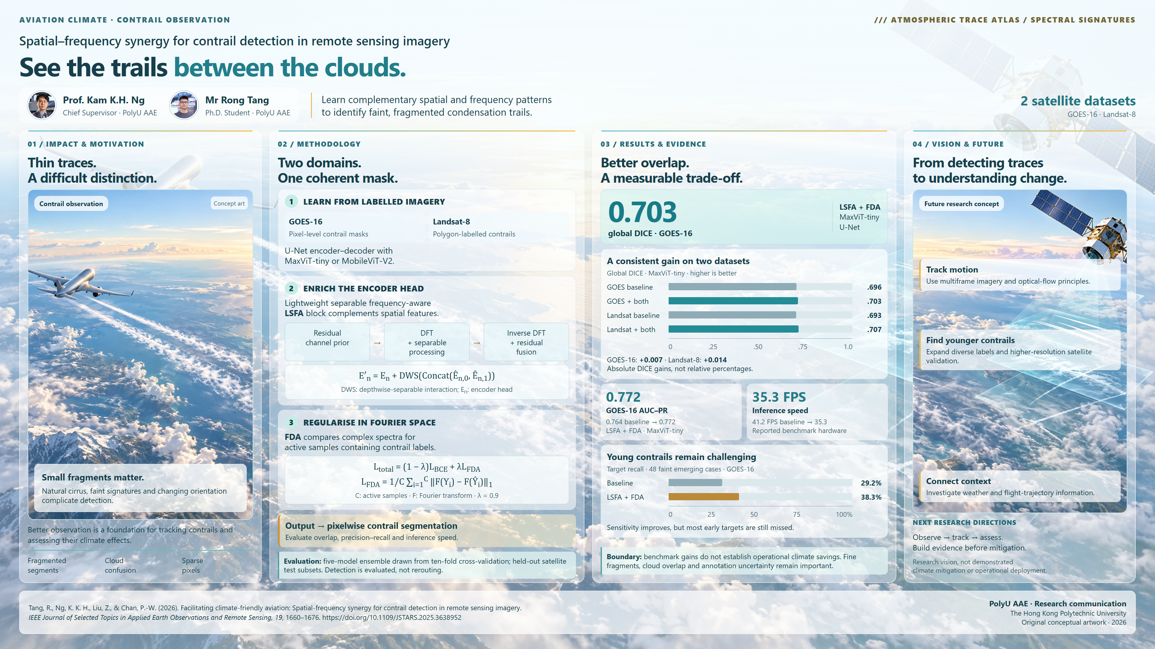
Research 2: Facilitating Climate-Friendly Aviation: Spatial-Frequency Synergy for Contrail Detection in Remote Sensing Imagery.
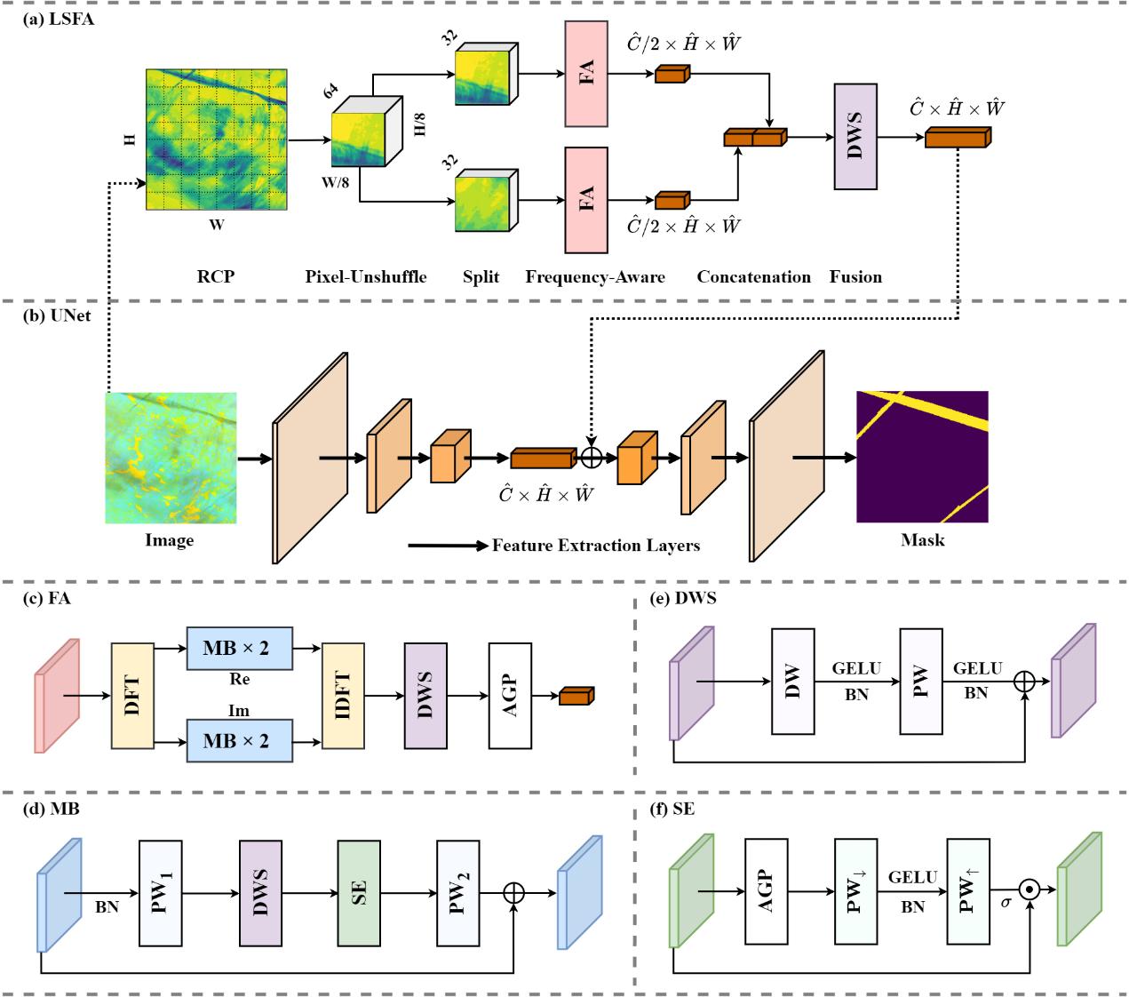
Frequency-aware LSFA block integrated into an encoder-decoder contrail segmentation architecture.
This work introduces frequency-oriented learning and regularization for satellite-based contrail segmentation. A lightweight separable frequency-aware block enriches feature extraction, while a frequency-domain alignment term reduces spectral differences between predictions and labels. Evaluations on human-labelled GOES-16 and Landsat-8 datasets show consistent gains across metrics with limited computational overhead, especially for short and fragmented contrails.
Main contributions of Research 2:
1) Established reproducible contrail-detection benchmarks across two satellite datasets with different resolutions and label granularities.
2) Designed the lightweight LSFA block and frequency-domain alignment regularisation for encoder-decoder segmentation models.
3) Demonstrated cross-dataset generalisation and improved detection of difficult, low-coverage contrail segments.
Research 3: A Learning-Based Interacting Multiple Model Filter for Trajectory Prediction of Small Multirotor Drones Considering Differential Sequences.
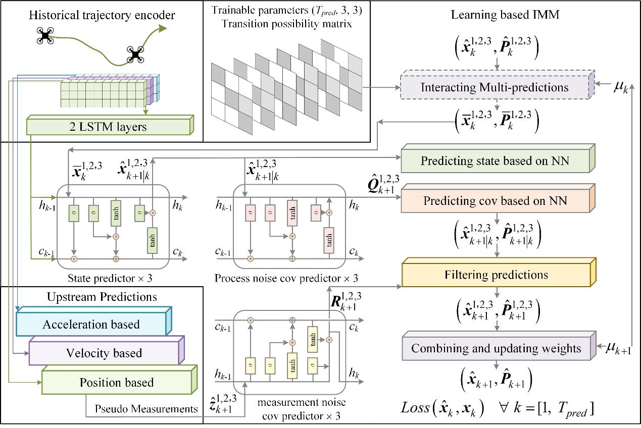
Learning-based interacting multiple model (LIMM) architecture for fusing position-, velocity-, and acceleration-based forecasts.
This study formulates non-cooperative multirotor trajectory prediction as multivariate time-series forecasting. Three modified Transformer models predict position, velocity, and acceleration sequences in parallel; a learning-based interacting multiple model filter then fuses them as pseudo-measurements. Experiments on 17 industrial and academic drone datasets show that velocity-based differential prediction improves accuracy and that the integrated method performs strongly on 15 previously unseen datasets while remaining suitable for real-time use.
Main contributions of Research 3:
1) Introduced parallel differential-sequence forecasting to capture diverse multirotor flight patterns from limited positional observations.
2) Embedded neural predictors within an interacting multiple model framework to learn transition probabilities and fuse complementary forecasts.
3) Validated accuracy, generalization, and real-time feasibility across 17 datasets representing industrial and academic applications.
Key Publications
Journal Paper
[1] Tang, R., Ban, W., Ng, K. K. H., Chan, P. K., & Wang, D. (2026). Estimating spatio-temporal contrail coverage: Fusing satellite observations, meteorology, and air traffic flow. Atmospheric Environment: X. (Accepted, 2026).
[2] Tang, R., Ng, K. K. H., Liu, Z., & Chan, P.-W. (2026). Facilitating climate-friendly aviation: Spatial-frequency synergy for contrail detection in remote sensing imagery. IEEE Journal of Selected Topics in Applied Earth Observations and Remote Sensing, 19, 1660-1674. https://doi.org/10.1109/JSTARS.2025.3638952
[3] Tang, R., Ng, K. K. H., Li, L., & Yang, Z. (2025). A learning-based interacting multiple model filter for trajectory prediction of small multirotor drones considering differential sequences. Transportation Research Part C: Emerging Technologies, 174, 105115. https://doi.org/10.1016/j.trc.2025.105115
Conference Paper
[1] Tang, R., Ng, K. K. H., Chen, Y., & Delahaye, D. (2026). Contrail-aware trajectory optimisation: Operational cost implications of different climate metrics. In Proceedings of the International Workshop on ATM/CNS (IWAC 2026), 2026, Tokyo, Japan.
[2] Tang, R., Ng, K. K. H., Chen, Y., & Xu, Y. (2025). Contrail detection and coverage estimation across air route traffic control centers from satellite observations. SESAR Innovation Days 2025, Bled, Slovenia.
[3] Tang, R., & Ng, K. K. H. (2025). Strengthening long-range dependencies in deep convolutional neural networks for contrails detection in satellite imagery. AIAA Aviation 2025 Forum, Las Vegas, Nevada, USA.