The New Geospatial Curriculum (NGC) was conceived as part of the Geospatial Education Forum Project funded by HKSAR University Grants Committee. The aim of the NGC is to put Geospatial Education into perspective, to identify the various components that contribute to Geospatial Education. The NGC is built upon a Framework established through Interviews and the Forum with the Project team. The Framework attempts to understand and structure the logic behind Geospatial Education.
The Project has revealed that even though Educators are experts in their field, their expertise may constrain them and can cause neglect towards the integration between their own subjects and others. The NGC hopes to remedy this by proposing a three-section structure, which sets out various components within each section and attempts to create links between each component and section. Each section (Foundation, Core, Specialised) contains a specific set of component that contributes to the study of Geospatial concepts. The depth of which the components are to be taught is dependent on the Programme type, length, and focus.
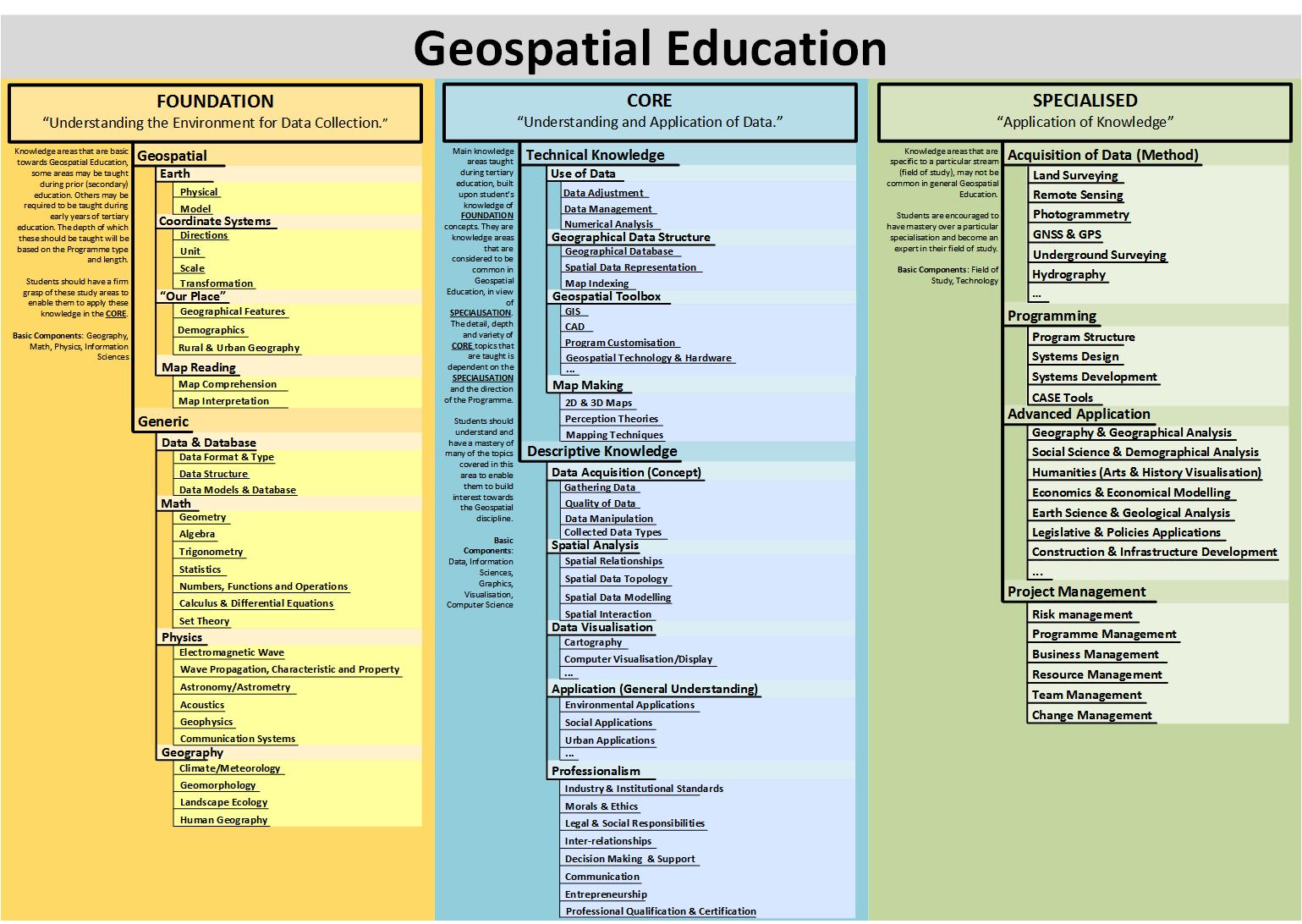
Foundation:
It involves components relating to the basic building blocks of Geospatial Education. These areas can be taught during secondary and early tertiary education. However, it would be most beneficial for the students to learn these components at the earliest stage of Geospatial Education. A sound understanding in this section is much preferred to enable smoother transition into the Core components of Geospatial Education. The meaning of “Foundation” is taken to mean the basis and groundwork where all further Geospatial knowledge would be built upon, it may not correspond to a particular Programme’s definition of Foundation subjects.
Core:
These components are built upon the students’ understanding of the Foundation components, they are the main knowledge areas taught during the course of Geospatial Education whether it be diplomas, graduate course, or post-graduate courses. These components are considered to be common in Geospatial Education in view of Specialisation. Some Programmes may choose to put more emphasis onto a particular component, whilst others may choose to simplify a particular component. Core components taught by educators are what defines the Geospatial Education Programme that would be experienced by the students.
Specialisation:
These components are taught to a specific discipline of learning under Geospatial Education. It may not be common in general Geospatial Education Programmes and are generally studied at later years of tertiary education or at post-graduate levels. These are high level components, building upon Core and Foundation components. Students who have not mastered components in the previous two sections will find it difficult to apply their knowledge in the current context under Specialisation.
The NGC aims to provide guidance to the structure of Geospatial Education courses to enable educators the ease of designing a comprehensive course. It strives to include many aspects of both traditional and modern conceptions of Geospatial Education, allowing for education of both the Analytical/Conceptual field and Practical/Technical field. The NGC takes into account the variety of students’ knowledge and expertise when entering the Geospatial field, hoping to develop interest and further knowledge of applications of Geospatial concepts.