The NGC Framework was established during the initial phase of the Project, where Team Members help identify the characteristics in the current Geospatial Curriculum structure. These identified characteristics showed the diversity between how different faculties, belonging to the Geospatial discipline, teach the same concepts but under different context.
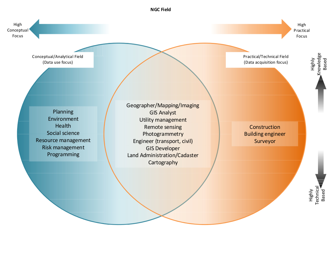
The intention of the Framework is to encompass all the Geospatial-related disciplines. To enable this, an understanding of the characteristics of these disciplines is required. Through the interviews and forum with the Team Members, the Project Team gathered that the concept of Geospatial is vast, diverse, and complex. It would be impractical to come up with a single definition and a single set of defining characteristic for determining what should be considered as the ‘traditional’ Geospatial discipline. The solution to this is to categorise the Geospatial-related disciplines in terms of how they make use of Geospatial concepts, whether they focus on use or on acquisition. The framework consists mainly of two sections: the Practical-Technical field, focusing on data acquisition, and the Conceptual-Analytical field, focusing on data use. From this framework, a preliminary NGC was built, which attempts to bring together the common topics taught under Geospatial Education.

The Framework uses four scales to aid users in identifying the field that they are operating on. It identifies the users in terms of how they use the Geospatial Information, how they gather the Geospatial data, and in what context they use the gathered information and data. Users are to examine whether their field of expertise relies on the conceptual use of data, practical use of data, requires high amounts of informational knowledge, or high degrees of technical mastery. Conceptual use (Conceptual-focused education) encompasses the analytical side, focusing on the application of data into context rather than the actual gathering of data. Practical use (Practical-focused education) of Geospatial data is the more hands-on side of Geospatial disciplines, it includes knowledge and skills in gathering and manipulation of data. Measured with these two scales are the Degree of Knowledge (Knowledge-based education) and the Mastery of Techniques (Technical-based education). The Degree of Knowledge is based on how well one comprehends the meaning behind the data, including the characteristics of Geospatial data and information, the various uses and modes of gathering the data and information, and the context that Geospatial data and information operates in. Mastery of Techniques requires the understanding of particulars for application of knowledge into context, and more specifically the real-world.