Mr Laurent Gutierrez and Dr Valérie Portefaix at the School of Design discovered the uneven development of Hong Kong in the course of urbanism. In relation, they proposed the construction of eight artificial islands and showcased this innovative idea at the Museum of Modern Art (MoMA) in New York.
What is the idea behind this "Hong Kong is Land" research project?
Invited by MoMA curator Pedro Gadanho, we developed a research project, "Hong Kong 2045", for the exhibition titled "Uneven growth: tactical urbanisms for expanding megacities". Featuring the future of six cities - Hong Kong, New York, Rio de Janeiro, Istanbul, Lagos and Mumbai, this exhibition was staged at MoMA, one of the world's most influential modern art museums.
In addition, we partnered with Net Lab of Colombia University in New York to imagine eight artificial islands in response to the development of Hong Kong. Our project named "Hong Kong is Land" expressed the universal values of the society through the design of lands.
What have you discovered regarding the uneven development in Hong Kong? How do you interpret the "islands" in your research?
Hong Kong is very different from other cities in terms of uneven development. The problem of slums absorbing new migrants in the city periphery was solved in the 1950s following the introduction of the unique public housing programme. We conducted the research from another angle and focused on the future of its economy and community with the city design in a new way. Apart from keeping an inventory on the uneven growth in Hong Kong, the project created islands with optimistic visions for the future and explored scenarios that might serve as paradigms for urban planning, housing density and population growth.
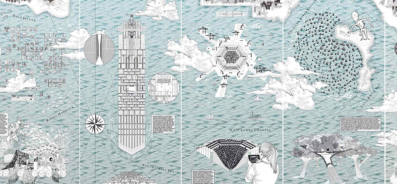
Completely out of the urban context, we finally came up with eight islands - Islands of Land, Sea, Self, Resources, Possible Escape, Surplus, Endemic Species and Memories.
What were the distinct features of the exhibition?
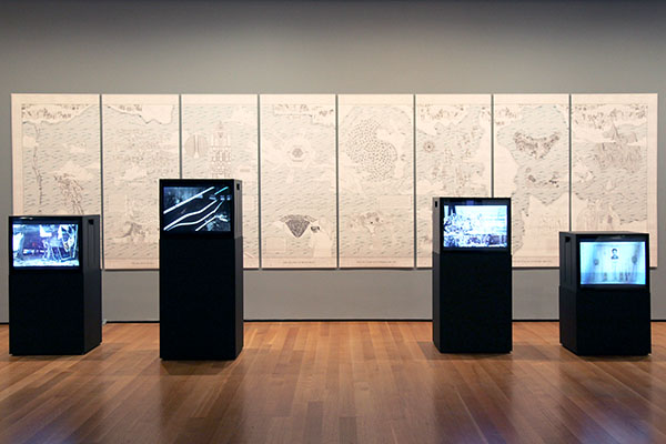
We produced a huge map (2 metres high by 8 metres long) for the exhibition so that visitors can easily comprehend the project. Led by cartography supervisor Gilles Vanderstocken, a team of seven undergraduate and master's students created that map to illustrate the design of the proposed artificial islands, including research on materiality, distribution of land use, morphology, cartography and representation.
We will also share the process of creating this exhibition at a public lecture titled "Island, archipelago, and other liquid territories" to be held on 5 January 2015 at PolyU.